Fun days for the South Coast, small windows on the Mid
South Australian Forecast by Craig Brokensha (issued Friday 4th May)
Best Days: Saturday South Coast, Sunday both coasts, Monday South Coast, Wednesday morning South Coast
Recap
Tiny waves across both coasts yesterday, with a building NW windswell across the Mid Coast into the afternoon.
This morning we've got a strong mix of groundswell and stormy windswell across the Mid Coast to 3-4ft+. Winds have backed off and the swell is also easing into this afternoon.
The South Coast saw bumpy workable 3-4ft waves this morning, and Middleton is still OK this afternoon with fresh W/SW breezes.
Today’s Forecaster Notes are brought to you by Rip Curl
This weekend and next week (May 5 – 11)
The intense mid-latitude low responsible for our current swells and wind has moved off to the east and across Victoria/Tasmania and with this we'll see the swell easing back through tomorrow.
Middleton is expected to ease back from 3ft+ while the Mid Coast should drop from 2-3ft with a moderate to fresh and persistent W/NW breeze.
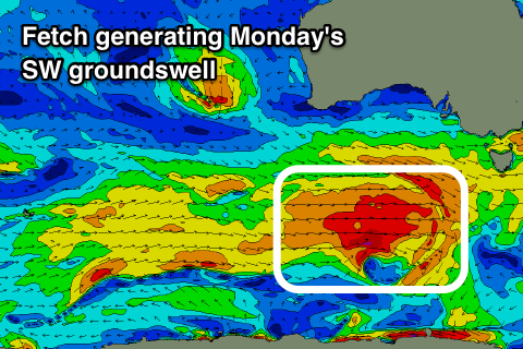
Into Sunday we should see a new W/SW groundswell, followed by a stronger SW pulse Monday morning.
 An initial fetch of pre-frontal W/NW gales moving in from the west today and south of us tomorrow will generating the initial W/SW swell Sunday.
A broader and stronger post-frontal W/SW fetch will generate a better SW groundswell for Monday morning.
The Mid Coast looks to hold 1-2ft through Sunday and Monday, while the South Coast should see 3ft sets off Middleton through Sunday morning, building later in the day and peaking around 4ft+ Monday morning.
Conditions on Sunday will be great for the South Coast with a persistent N/NW breeze, while the Mid Coast should see workable N/NE-N winds. Monday will be best down South with a fresh N/NW breeze, possibly giving into alate afternoon change as a trough moves in from the west.
The models are still slightly divergent regarding this trough but in any case winds look to revert back to the E/NE Tuesday morning with some reinforcing SW groundswell from the earlier stages of the frontal progression generating Sunday/Monday's swells.
Middleton should hold around 3ft+ while the Mid Coast is expected to drop back in size, with cleaner easing surf Wednesday.
Into the end of the week a mix of new SW groundswell for Thursday from another pre-frontal W/NW fetch and longer-period inconsistent swell Friday should keep the South Coast active, but winds will be less than ideal and from the south-eastern quadrant. More on this Monday.
Have a great weekend!

