Strong W/SW groundswell Friday for the Mid Coast
South Australian Forecast by Craig Brokensha (issued Wednesday 2nd May)
Best Days: Mid Coast stormy haunts Friday morning, South Coast Saturday, both coasts Sunday, South Coast Monday
Recap
Tiny bumpy waves on the Mid Coast with clean good conditions down South, best at more exposed breaks for a bit of size, while this morning the surf is small to tiny, but clean again. The Mid was tiny with a mild northerly wind but some new swell lines are appearing with sets to 1ft+.
Today’s Forecaster Notes are brought to you by Rip Curl
This week and weekend (May 3 - 6)
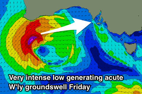
Currently south of WA a vigorous and mid-latitude low is projecting a fetch of gale to storm-force W/SW winds through our western swell window, with the low pushing east through the Bight while continuing to produce a severe-gale fetch this evening and tomorrow.
The low will push very north and out of the South Coast's swell window but remain in the Mid Coast's window, pushing across us tomorrow afternoon and then dipping more through the South Coast's swell window Friday morning.
What we can expect is no size across the South Coast at all tomorrow, while the Mid Coast will be a bumpy 1ft with a fresh N'ly, while strengthening W/NW winds into the afternoon will see stormy sets building to 2-3ft later in the day.
 Come Friday though we'll see the groundswell from the strongest part of the low filling in. This will produce 3-4ft of W/SW groundswell for the Mid Coast Friday morning, though there'll be plenty of windswell on top to 2-3ft, so 5ft bomb sets aren't out of the question, easing through the day.
The South Coast looks to offer weaker surf, only likely 2-3ft off Middleton Friday morning but building to 3-4ft into the afternoon.
Winds on Friday look poor with strong W/SW breezes due across all locations, with the strength looking to override any local affects around Victor that may steer winds W/NW.
The swell should ease across both coasts into Saturday, from 2-3ft on the Mid Coast and 3ft+ off Middleton with a more favourable W/NW breeze that looks to persist most of the day.
Moving into Sunday we should start to see some new W/SW swell building across the region followed by fun SW energy early next week.
A strong frontal progression moving in from the west from Friday will see a fetch of pre-frontal W/NW gales generating a new W/SW groundswell for Sunday, with a better aligned fetch of slightly stronger W/SW winds generating a bigger SW groundswell for Monday.
The Mid Coast looks to come in around 1-2ft all day Sunday, holding Monday, while Middleton should offer 2-3ft waves all of Sunday, kicking to the 4ft range on the sets Monday.
Conditions look favourable for both coasts Sunday with light local morning offshore winds, possibly variable into the afternoon, and then stiffer N'ly winds Monday. A surface trough moving through Monday evening looks to bring S/SE winds Tuesday, but more on this Friday.

