Great South Coast waves tomorrow, large stormy W/SW swell late week
South Australian Forecast by Craig Brokensha (issued Monday 30th April)
Best Days: South Coast tomorrow and magnets Wednesday morning, Mid Coast keen surfers later Thursday and Friday, protected spots down South Friday, South Coast Saturday
Recap
Fun waves across both coasts Saturday with a drop in swell from Friday and improving conditions across the South Coast with 3ft waves off Middleton. The Mid Coast was back to a tiny 1ft+.
A new pulse of W/SW swell for Sunday morning provided fun 1-2ft sets across the Mid Coast, but a much stronger and more powerful W/SW groundswell kicked through the afternoon with pumping 2-3ft+ waves until dark.
The South Coast was a peaky and smaller 2-3ft, bumpy into the afternoon as the new swell muscled up. This morning the swell has eased back quicker than expected with inconsistent 3-4ft sets left off Middleton this morning and 2ft waves on the Mid Coast.
Today’s Forecaster Notes are brought to you by Rip Curl
This week and weekend (May 1 - 6)
Our current swell will continue to ease over the coming days, dropping back from 3ft on the sets along the Middleton stretch and 1-1.5ft on the Mid Coast, smaller from 1-2ft and 0.5-1ft respectively Wednesday.
Conditions will be excellent for the South Coast with a moderate to fresh N/NE tending lighter N/NW breeze tomorrow and persistent N/NW winds Wednesday.
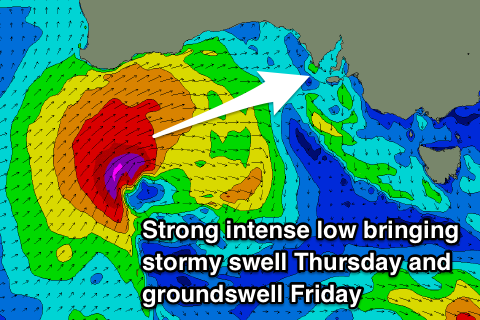
Moving into Thursday and Friday, we're set to see a large stormy W/SW swell developing across the Mid Coast, with windy workable waves across the South Coast.
This will be generated by a relatively weak polar front projecting up towards the southern WA coast tomorrow, deepening significantly while pushing east through the Bight.
We're expected to see a fetch of severe-gale to storm-force W/SW winds projected through the Mid Coast's swell window, weakening as the system pushes across us Thursday afternoon.
 A large W/SW groundswell will be created by the W/SW fetch for Friday, but with the front racing ahead of this, we'll see a stormy increase in W/SW swell Thursday from 0.5-1ft early to 3ft into the late afternoon.
The South Coast isn't due to any size until late, maybe hitting 2ft+ off Middleton with strong W/NW winds.
The groundswell for Friday should come in at a large 3-4ft on the Mid Coast, dropping through the day, with Middleton coming in at 3-5ft with the west direction though persisting most of the day.
Winds will remain poor for the Mid Coast but back off, best in protected spots down South with a gusty W/NW breeze, lasting until early afternoon before shifting W/SW.
Another much weaker front pushing in through the Bight should slow the easing trend Saturday, with dropping sets from 3-4ft off Middleton and 2ft+ on the Mid Coast.
Winds will swing around to the NW with another approaching front, freshening and tending back W/NW into the afternoon.
This mid-latitude front will spawn off a stronger polar frontal progression developing south-west of WA later this week, and we'll see good pulses of W/SW and SW groundswell from Sunday into early next week. Winds look as if they'll go a little funky and swing onshore Sunday, but a low moving in from the west may swing winds back N/NE Monday/Tuesday. More on this Wednesday.

