Good W/SW swells inbound with favourable winds
South Australian Forecast by Craig Brokensha (issued Monday 23rd April)
Best Days: Mid Coast Wednesday, both coasts Friday morning, South Coast Saturday morning, Mid Coast late Sunday, both coasts Monday
Recap
Great little clean waves on the Mid Coast Saturday with Friday's building W/SW swell peaking under light winds, while the South Coast was clean but tiny.
The W/SW swell backed off into Sunday leaving tiny waves on the Mid and South Coast's.
A very inconsistent long-range W/SW groundswell filled in yesterday afternoon offering infrequent 1-2ft sets off Middleton, while keeping tiny 1ft waves hitting the Mid Coast, with similar surf today, best at swell magnets on the South Coast.
Today’s Forecaster Notes are brought to you by Rip Curl
This week and weekend (Apr 24 - 27)
We've got a slow couple of days ahead, especially for the South Coast with out current inconsistent W/SW groundswell due to fade tomorrow under early W/NW tending SW winds.
The Mid Coast will be tiny but later in the day and more so Wednesday a small W/SW swell is due, generated by a now weaker mid-latitude low dipping across the south-west corner of WA and projecting a weak fetch of 20-25kt W/SW winds through the Bight today before weakening tomorrow.
We may see a late increase in swell tomorrow, but Wednesday should reveal 1-2ft waves and a light variable wind should create clean conditions before a W'ly tending W/SW breeze kicks in linked to an approaching front.
The swell will be too west for the South Coast with maybe the odd 2ft set at magnets with a light morning NW breeze, tending W/NW and then W/SW.
A temporary drop in W/SW swell is expected Thursday morning with S/SW tending S/SE winds, but moving into the afternoon and more so Friday we should see some good new W/SW groundswell.
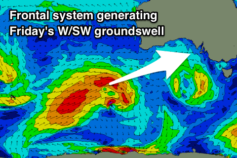
 A strong polar frontal progression that's currently south-west of WA is producing a good fetch of gale to severe-gale pre-frontal W/NW and post-frontal W/SW winds while projecting slightly east-northeast towards us.
We'll see weaker remnants of this storm push under the Bight Wednesday and under us into the evening, with an afternoon increase in mid-period W/SW swell due Thursday ahead of the groundswell on Friday.
The Mid Coast may see 1-1.5ft sets later Thursday with 2ft sets off Middleton, though with that S/SE breeze, while Friday should reveal better 2ft waves on the Mid Coast and 3-4ft sets off Middleton.
Winds look favourable for both coasts Friday with a E/NE-NE offshore in the morning ahead of sea breezes.
Saturday looks great as well as the swell eases under N/NE offshores, favouring the South Coast as the Mid Coast will become tiny.
A temporary low point is expected Sunday morning, but into the afternoon some good new W/SW groundswell is due. This will be generated by a vigorous storm developing west-southwest of WA, aiming various fetches of severe-gale to storm-force W/SW and SW winds in our western swell window.
An initial increase in W/SW groundswell is due early Sunday ahead of a stronger pulse Sunday afternoon/evening.
We're likely to see the Mid Coast kicking back to 2ft late in the day, holding a similar size on the sets Monday, with Middleton building to 3-4ft+ later Sunday and offering 3-5ft waves Monday morning.
Winds are looking favourable at this stage and from the NE, but check back here Wednesday for more on this.

