Clean easing S/SW groundswell, quiet until late next week
South Australian Forecast by Craig Brokensha (issued Wednesday 18th April)
Best Days: Thursday until mid-afternoon South Coast, Friday morning swell magnets on the South Coast, afternoon Mid Coast and Saturday morning, Monday morning South Coast
Recap
Fun waves hanging in around 1-2ft on the Mid Coast yesterday with clean conditions most of the day, while the South Coast provided plenty of size but less than ideal conditions with easterly breezes.
Today is much better with a new S/SW groundswell providing solid 4-5ft sets across most exposed breaks with an offshore northerly-northeast wind.
Today’s Forecaster Notes are brought to you by Rip Curl
This week and weekend (Apr 19 - 22)
Today's S/SW groundswell will start to ease through this afternoon, dropping further from 3ft+ off Middleton tomorrow morning, tiny on the Mid Coast.
Friday will become minimal with small to tiny surf off Middleton, only surfable at Waits and Parsons.
The Mid Coast however should see tiny levels of W/SW swell from later tomorrow but more so Friday through Saturday, generated by a weak but persistent mid-latitude low through our western swell window.
This low is currently under WA but will weaken through tomorrow.
1-1.5ft waves are likely Friday and Saturday, with sets to 2ft on the favourable parts of the tide, fading Sunday.
Coming back to the local winds and tomorrow will be great most of the day across the South Coast with a N tending N/NW breeze, variable ahead of weak afternoon sea breezes.
Friday will be good again with a N/NE morning breeze, tending NW into the afternoon.
 Offshore N tending NW winds are due to persist across the region Saturday but the surf will remain tiny down South, though through Sunday and Monday a new long-range and very inconsistent long-period W/SW groundswell should fill in.
This swell has been generated by a very large storm in the southern Indian Ocean, with oversized swell due across WA and Indo, but by the time the swell reaches us it will hardly have any size.
We should see a very inconsistent signal of swell building Sunday and reaching 1ft on the Mid Coast, persisting around a similar size Monday.
The South Coast will struggle to see much size, with possible sets to 2ft off Middleton Sunday afternoon and 2ft to occasionally 3ft Monday morning with morning offshore winds.
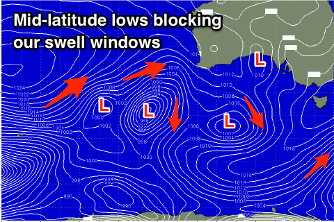
Longer term there's nothing significant due until next weekend as cut-off lows setup to our west and south-west block our main swell windows. The Mid Coast may see small levels of W/SW swell, but we'll review this and a break down of the blocking pattern on Friday.

