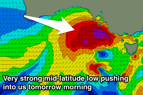
Large stormy surf building tomorrow, easing Sunday and improving, further into next week
South Australian Forecast by Craig Brokensha (issued Friday 13th April)
Best Days: Stormy waves tomorrow, protected locations Sunday down South, Monday morning South Coast, Tuesday both coasts, Wednesday and Thursday mornings South Coast
Recap
Poor conditions with a building windswell through yesterday afternoon across the Mid Coast to the 2-3ft range, while the South Coast was clean and small through the morning, building more to 3ft on the sets into the afternoon as winds held from the west.
This morning the swell eased back across both coasts but the South Coast was super clean and fun with 2-3ft sets hanging in at Middleton, while the Mid was a poor 1-2ft. We've now got a building NW windswell across the Mid Coast along with strengthening N/NW winds.
Today’s Forecaster Notes are brought to you by Rip Curl
This weekend and next week (Apr 14 - 20)
Today's strengthening NW-W/NW winds are associated with the first to two vigorous mid-latitude fronts pushing up and into the state, the second for tomorrow being quite severe and stronger than forecast on Wednesday.
 The mid-latitude low is currently south-west of us and we'll see a fetch of severe-gale to near storm-force SW winds projected right into the south-east of the state tomorrow morning.
We're expected to see large stormy and powerful surf developing down South, reaching 6-8ft off Middleton and around Victor into the afternoon, while the Mid Coast is due to kick to a stormy 4-5ft.
Conditions will be wild and wooly with strong to gale-force W/NW winds tomorrow morning, swinging W/SW into the afternoon and easing a little.
The low will dip south-east while stalling slowly, aiming an additional fetch of SW gales in our south-western swell window Saturday evening, before dipping further away to the south-east Sunday.
This will result in the swell easing back through Sunday from 3ft range on the Mid Coast, and 5-6ft+ range across the South Coast with fresh to strong W'ly winds. The Victor region is likely to see morning W/NW winds, creating favourable conditions in protected spots.
The swell will continue to ease into Monday, but a good reinforcing SW groundswell is due into the afternoon, generated by a much weaker but good mid-latitude front pushing in from the Indian Ocean and under the Bight on the weekend.
Middleton looks to drop back from 4-5ft Monday morning, holding around 4ft into the afternoon, easing slowly through Tuesday.
The Mid Coast should see waves hanging in around 2ft range through Monday, easing off slowly through Tuesday.
Winds Monday morning should be good for the Victor region again with a W/NW'ly, shifting W/SW-SW into the afternoon, while Tuesday a high will quickly move in from the west, bringing light offshore winds to the Mid, and variable tending NE winds down South.
Our large S/SW groundswell mid-week has been downgraded a little with a strong final polar frontal system forming a little later in our swell window. We should still see a solid S/SW groundswell pulse for later Wednesday and Thursday morning along with morning NE winds, but we'll review this Monday. Have a great weekend!

