Great Saturday and fun Sunday morning with new swells early next week
South Australian Forecast by Craig Brokensha (issued Friday 30th March)
Best Days: Saturday both coasts, Sunday morning South Coast, possibly Mid Coast early Monday, Mid Coast Tuesday morning
Recap
Tiny building surf across the Mid Coast yesterday from 1-1.5ft in the morning with 1-2ft into the afternoon with weak onshore winds. The South Coast was small to tiny early, but some new swell kicked later in the day, peaking today to a good clean 3-4ft off Middleton early, but winds have since shifted onshore.
The Mid Coast has continued in the 2ft range on the sets with weak onshore winds. Some better sets are now showing on the coast and this afternoon's incoming tide should help push this.
Today’s Forecaster Notes are brought to you by Rip Curl
This week and weekend (Mar 31 – Apr 6)
Tomorrow is looking really fun across both coasts as we see today's W/SW groundswell replaced by a new reinforcing S/SW swell mostly favouring the South Coast.
The frontal system responsible for today's swell has stalled and seen a polar low pressure system form, with a stationary fetch of strong to gale-force W/SW winds being generating through our southern swell window.
This swell should fill in tomorrow and keep Middleton persisting in the 3-4ft range all day, dropping back from 3ft on the sets Sunday morning.
The Mid Coast is due to ease back from 2ft on the sets and conditions will be great across both regions with local offshore winds from the north-eastern quadrant tomorrow morning, tending variable ahead of early-mid-afternoon sea breezes.
Sunday looks good early with light offshore N winds, tending more W'ly ahead of sea breezes and a more pronounced change later in the day.
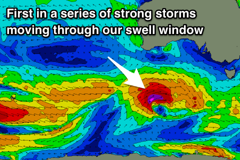
 Moving into Monday and we've had an upgrade in the swell, with one of the embedded fronts mentioned the last few updates expected to intensify significantly south-west of WA today.
We'll see a great fetch of gale to severe-gale W/SW winds (even possibly storm-force) projected east through our south-western swell window, producing a strong SW groundswell for Monday morning.
A secondary slightly weaker front will then generate a secondary reinforcing SW groundswell for later in the day and Tuesday morning.
We should see the Mid Coast kicking back to 2ft on Monday, more so 1-2ft Tuesday with Middleton coming in at 4-5ft Monday morning (likely 6ft bombs), hanging around 3-5ft into Tuesday morning.
Winds will unfortunately be onshore from the S/SW in the wake of Sunday's late change, (possibly S'ly early on the Mid Coast) but Tuesday looks cleaner with a morning S/SE breeze, still lingering onshore down South.
Into Wednesday better E/NE-NE winds are due down South and we may see some new swell later in the day but more so Thursday. More on this Monday though. Have a great weekend!

