Poor run for the South Coast with good swells next week
South Australian Forecast by Craig Brokensha (issued Friday 18th January)
Best Days: No good days down South, Mid Coast beginners Monday, Tuesday, fun boards Wednesday
Recap
Wednesday afternoon's incoming pulse of W/SW swell to 1-1.5ft backed off to 0.5ft yesterday, increasing to 0.5-1ft again into the afternoon. This morning it was back to the near tiny stuff with a freshening N'ly.
The South Coast was great yesterday with good sets hanging in at 2-3ft off Middleton through the morning with all day offshores, while today the swell was back to 1-2ft off Middleton with a morning offshore. An onshore change is just starting to move in from the west now.
Today’s Forecaster Notes are brought to you by Rip Curl
This week and weekend (Jan 20 – 26)
Today's onshore change will signal an extended poor run of summer south-east slow down South, and to be honest it's the first real episode of the season (we've had a pretty good run of local winds).
The reason for the poor winds will be a large stubborn high moving slowly into the Bight and remaining so through the weekend and most of next week as a couple of strong cold fronts try and dislodge it from the south.
 Over the weekend we'll see a strong fetch of S/SE winds aimed into the South Coast, kicking up a junky S/SE windswell to 3ft or so tomorrow, smaller and to 2-3ft on Sunday.
The Mid Coast will be flat tomorrow, while into Sunday were due to see some new SW groundswell kicking later in the day.
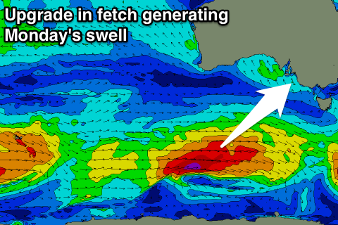
This swell which is expected to peak Monday morning has been upgraded in size and power.
The swell is being generated by an elongated and good polar frontal progression. This progression has been upgraded in strength with a fetch fetch of W/SW gales moving through our south-western swell window from last night through today before weakening tomorrow morning.
A late pulse in size is expected Sunday to 3ft+ on the sets down South at Middleton, and maybe 0.5-1ft on the Mid ahead of a peak Monday morning to a solid 4ft on the sets off Middleton, as the Mid holds 1ft. Gusty S/SE-S winds will only favour the Mid Coast and continued to create poor conditions down South.
A drop in swell is expected through Tuesday morning, but into the afternoon and more so Wednesday a secondary pulse of SW groundswell is due.
This will be generated by a more northerly placed mid-latitude frontal progression with a fetch of strong to nearly gale-force W/SW winds being generated through our swell window.
The position of the progression will be slightly better for the Mid Coast, with Wednesday likely to reveal 1-1.5ft sets on the favourable parts of the tide. Middleton looks to come in at 3-4ft with SE tending S/SE winds.
Into the end of the week there's no real let up in the unfavourable winds until Saturday. More on this Monday. Have a great weekend!

