Marginal weekend, better mid-late next week
South Australian Forecast by Craig Brokensha (issued Friday 12th January)
Best Days: Keen surfers Saturday morning down South, similar keen surfers Mid Coast Sunday, South Coast Wednesday and Thursday
Recap
Good fun 1-1.5ft waves on the Mid Coast yesterday with favourable winds all day, while the South Coast was also good with great waves at Waits and Parsons.
This morning the swell was smaller on both coasts and a morning N'ly favoured swell magnets down South but a change has now moved through.
Today’s Forecaster Notes are brought to you by Rip Curl
This week and weekend (Jan 13 – 19)
Today's change is due to a relatively weak mid-latitude front pushing in from the west, and it will be followed by by a secondary system tomorrow, but the strength of this has been downgraded unfortunately.
This will impact the swell size expected on Sunday across the Mid Coast.
But coming back tomorrow and we're due to see less than ideal conditions with an onshore 1-1.5ft wave on the Mid Coast and small weak leftover 2ft sets across Middleton with a morning W/NW breeze, tending SW through the day.
This change will kick up some poor windswell for the South Coast Sunday that'll be lucky to top 2-3ft along with poor S/SE winds.
The Mid Coast looks to now come in around 1-1.5ft, with 2ft sets on the favourable parts of the tide if we're lucky. At least conditions will be decent.
Moving into Monday and we'll see the W/SW and S/SW swells fade (1ft on the Mid) as SE winds favour the Mid and create poor conditions down South.
 A temporary low point in swell is due early Tuesday morning ahead of an increasing in new long-period SW groundswell through the afternoon, peaking Wednesday.
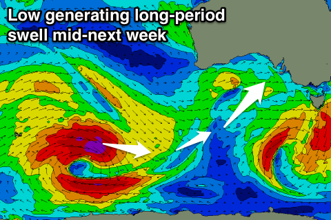
This groundswell is starting to be generated today as two cyclones from the Indian Ocean along with an injection of cold air result in the formation of a 'bombing low' in the Southern Ocean.
We're expected to see a fetch of severe-gale to storm-force W-W/NW winds generated in our swell window today, persisting tomorrow morning as the low stalls and slowly weakens. We'll see the fetch swing a little away from us through Sunday as the low starts moving east, but by then, we'll already have seen a moderate to large sized long-period SW groundswell generated.
The swell should start building Tuesday, reaching an easy 3ft across Middleton by dark with 0.5-1ft sets on the Mid Coast, while a peak is expected Wednesday morning to an inconsistent 4-5ft off Middleton with 1ft surf on the Mid, possibly pulsing to 1.5ft with the favourable parts of the tide.
Winds on Tuesday morning will swing from the E to SE through the day, but Wednesday looks great with a light NE offshore before sea breezes kick in. Thursday looks the cleanest and straightest with a fresher N'ly offshore as the swell eases.
Longer term a developing mid-latitude low should generate some new swell next weekend, but more on this Monday. Have a great weekend!

