Easing improving surf, great W/SW swell for Sunday
South Australian Forecast by Craig Brokensha (issued Wednesday 3rd January)
Best Days: South Coast Thursday, Friday and Saturday mornings, Mid Coast Sunday
Recap
A continuation of clean 1-1.5ft waves on the Mid Coast yesterday, while the South Coast was poor with onshore winds though plenty of swell.
This morning the swell was dropped a touch across both coasts, back to 1ft+ on the Mid and an average 2-3ft down South, but we should see a new S/SW swell filling in this afternoon keeping Middleton around 3ft (tiny on the Mid).
Today’s Forecaster Notes are brought to you by Rip Curl
This week and weekend (Jan 4 – 7)
This afternoon's S/SW groundswell should hold around a similar size into early tomorrow morning down South, that being 3ft on the sets along the Middleton stretch, and a light E/NE-NE wind will create cleaner conditions, though there'll still be a lot of wobble and lumpiness.
The Mid Coast should see leftover fading 1ft sets, easing through the day.
A temporary low point in swell will be seen through Friday morning with similar E/NE-NE breezes across the South Coast and 2ft surf off Middleton. A new pulse of S/SW swell is expected to arrive late morning though, generated by a small fetch of W/SW gales currently well south of WA.
This should provide a little more size into the afternoon to 2ft+ off Middleton, but not influence the Mid Coast.
 With this pulse, Saturday morning's prospects are now a touch better with a an early fresh N'ly wind and fading 1-2ft waves off Middleton, better to 2-3ft at Waits and Parsons ahead of a early afternoon SW change.
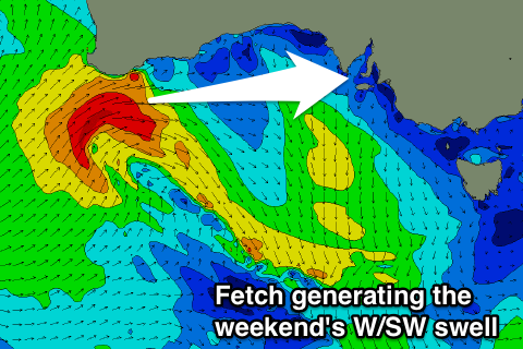
The front linked to this change has been upgraded since Monday and with this, so have the swell prospects for the Mid Coast.
We'll see the front will strengthen directly south of WA on Friday, projecting a tight but ideal fetch of gale to severe-gale W/SW winds through the Mid Coast's swell window.
As the front races east through the Bight it will weaken, then allowing a high to quickly ridge in from the west.
What we'll see is a moderate sized W/SW groundswell generated for Sunday, peaking during the day to a strong 2-3ft on the Mid Coast with a morning S/SE-SE breeze. The swell will be quite west for the South Coast and only likely build to 2-3ft of Middleton but with those poor winds.
Come Monday the swell will drop back from 2ft on the Mid and 2-3ft down South as another front moves in from the west, bringing some new swell mid-week. But more on this Friday.

