Good swell over the weekend, light winds Sunday
South Australian Forecast by Craig Brokensha (issued Wednesday 27th December)
Best Days: Saturday morning protected spots down South, both coasts Sunday morning
Recap
Improving fun waves across the South Coast yesterday morning with light offshore winds, while the Mid Coast was effectively flat. Similar conditions were seen on the Mid Coast this morning while the South Coast was much smaller and best at Waits and Parsons.
Today’s Forecaster Notes are brought to you by Rip Curl
This week and weekend (Dec 28 - 31)
Tomorrow is still a lay day with the swell expected to bottom out along with an onshore change. Variable winds might be seen at dawn around Victor but there'll be no size.
There may also be a tiny hint of new long-range W/SW groundswell across the Mid Coast into the afternoon but not likely above 1ft.
Into Friday though we'll see the first noticeable increase in W/SW groundswell across the state, generated by a distant mid-latitude front pushing towards WA from the Indian Ocean.
The Mid Coast should see inconsistent 1ft surf, with 1.5ft sets on the favourable parts of the tide (though not a big movement). The South Coast is only due to see similar 1-1.5ft waves off Middleton, bigger at Waits and Parsons.
Winds look as if they'll linger from the S'th on Friday, though be light and possibly variable across the South Coast, creating OK conditions for keen surfers. The Mid Coast will be cleaner with a morning S/SE breeze before SW sea breezes kick in.
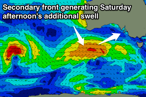
Over the weekend we'll see some stronger and larger W/SW swell filling in, generated by back to back mid-latitude fronts projecting from south-west of WA under the country.
There's been a slight upgrade in the strength of the secondary system, resulting in more size.
 The first swell is due to peak Saturday morning, generated by strong W/SW winds moving through our western swell window.
We should see good 2-3ft waves off Middleton and 2ft sets on the Mid Coast, but into the afternoon the secondary stronger W/SW groundswell is due. This will be generated by a stronger fetch of W/SW winds pushing in under the country tomorrow afternoon and Friday.
If the tide were on the way in we could expect 3ft sets on the Mid Coast, but the outgoing phase will likely limit sets to 2ft+. The South Coast should see Middleton building to 3-4ft.
Unfortunately winds will be onshore for the Mid Coast and from the W/SW tending SW, but the Victor region should see a morning W/NW breeze, creating fun waves in protected spots.
The swell should ease back through Sunday from 2ft+ on the Mid Coast and 3ft+ off Middleton with light SW tending variable winds creating OK conditions across both regions. It won't be perfect but should be fun.
Into the New Year follow up mid-latitude frontal activity should generate some additional SW swell for Monday/Tuesday but winds look worse and from the southern quadrant. More on this Friday.

