Fun couple of days on the South Coast before onshore winds kick in
South Australian Forecast by Craig Brokensha (issued Monday 27th November)
Best Days: South Coast tomorrow morning and Wednesday, Mid Coast Friday afternoon
Recap
Tiny clean waves for beginners on the Mid Coast Saturday, near flat Sunday, while the South Coast only offered a wave at swell magnets Saturday morning, onshore and poor yesterday.
Today the surf was poor again down South with tiny onshore winds, clean and tiny on the Mid, but a new SW swell has hit the Cape du Couedic wave buoy and we should see sets hitting 1-1.5ft on the Mid Coast with the incoming tide and 3ft at Middleton later this afternoon.

Today’s Forecaster Notes are brought to you by Rip Curl
This week and weekend (Nov 28 – Dec 3)
This afternoon's increase in SW groundswell was generated by a strong polar low firing up south-west of WA late last week, and we should see it peaking overnight, dropping back through tomorrow from 2-3ft off Middleton and 1ft on the Mid Coast.
Winds are now looking better for the South Coast tomorrow, with a dawn E/NE'ly, tending NE through the mid-late morning and even likely N/NE before sea breezes kick in.
This will create improving conditions, cleanest late morning before the sea breeze hits.
Wednesday looks great as well, with a small reinforcing SW swell keeping Middleton up around 2ft+ during the morning, while the Mid Coast is due to ease a touch to 0.5-1ft. A morning N/NE offshore is expected to swing N/NW through the day ahead of a possible late change, but conditions should remain clean until at least mid-afternoon.
 Thursday's possible late change will be linked to a weak but strengthening surface trough drifting in from the west, and it may linger just west of us Thursday morning, resulting in variable winds, but the surf will be tiny and fading from 1-1.5ft at Middleton.
Freshening S/SW winds will move in through the morning though, with a building S/SE windswell due to take place slowly though Friday but more so over the weekend as the trough deepens just west of Tassie.
This will be along with poor S/SW winds, and no quality options to surf.
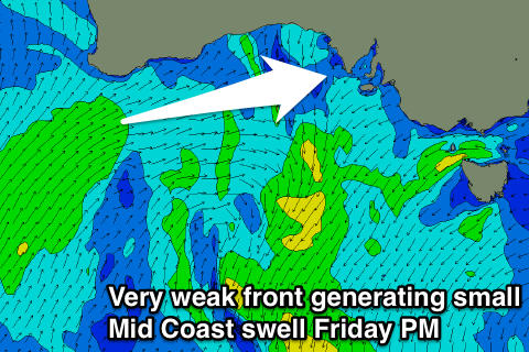
A small sneaky W/SW swell is due for the Mid Coast though Friday afternoon, produced by a very weak but slow moving and favourably tracking front up and under WA mid-week.
We should see sets reaching 1-1.5ft with small incoming tide, if not for the odd bigger one at magnets, fading back from 1ft to maybe 1-1.5ft Saturday with those S'ly winds.
Longer term there's nothing too major on the cards with poor winds and no decent groundswell likely through next week, but more on this Wednesday.

