Easing W/SW swell, cleanest on the Mid Coast
South Australian Forecast by Craig Brokensha (issued Wednesday 22nd November)
Best Days: Mid Coast tomorrow on the favourable parts of the tide, depending on local winds, South Coast tomorrow morning
Recap
Flat surf across the Mid Coast yesterday morning before some new W/SW energy showed into the afternoon, coming in at 1ft on the sets. The South Coast was clean but tiny and only surfable at Waits and Parsons.
Similar waves have been seen this morning across both coasts, though the Mid Coast is seeing some better sets to 1.5ft now.
We should see a stronger increase in W/SW groundswell through this afternoon, providing 2ft sets on the Mid Coast with the help of the incoming tide, while Middleton should build to 3ft by dark.
Today’s Forecaster Notes are brought to you by Rip Curl

This week and weekend (Nov 23 - 26)
This afternoon's increase in W/SW swell is due to peak overnight and ease back through tomorrow across both coasts.
The Mid Coast should ease back from 2ft on the sets, though the early high tide isn't ideal at all (likely swallowing the swell), with tiny 1ft waves Friday.
Middleton should ease back from an inconsistent 3ft on the sets, smaller and fading from a max of 2ft Friday morning.
Winds tomorrow are still tricky as a trough/low moves in slowly from the west. The Mid Coast is guaranteed to be clean with light winds from the SE-E/SE, but the South Coast is a little dicey. We should see variable winds, though they may be lingering from the S/SE and will increase through the day.
Friday is still also a little undecided, with possible variable winds from the E down South, though the swell will be small, inconsistent and fading.
Moving into the weekend there's no new swell due at all, with tiny fading surf due down South Saturday morning along with a light W/NW breeze during the morning ahed of a shallow SW change.
 Sunday will be smaller again with less than ideal and weak W/SW winds.
Of greater importance is the swell due early next week across the state.
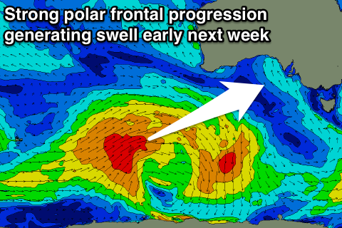
As touched on last update, a strong polar frontal progression is expected to form south-west of WA over the coming days, generating a moderate sized SW groundswell for later Monday ahead of a reinforcing pulse Tuesday.
The swell should hopefully have enough size to provide 1-2ft sets on the Mid Coast, with 3-4ft sets likely off Middleton, though with winds from the eastern quadrant. We'll have a closer look at this Friday though.


Comments
Good sets now showing on the Mid, the incoming tide should give it a great push..