Fun waves at magnets tomorrow, poor thereafter
South Australian Forecast by Craig Brokensha (issued Monday 13th November)
Best Days: Tuesday South Coast swell magnets, Sunday morning South Coast swell magnets
Recap
Fun waves across exposed breaks Saturday while Sunday was smaller but still fun with the great weather. The Mid Coast was tiny all weekend, though later yesterday some tiny new lines of W/SW swell appeared, coming in around 1ft+ today. The South Coast also offered a touch more size with light offshore winds.
This week and weekend (Nov 14 - 19)
Today's W/SW groundswell was generated by a strong distant mid-latitude low in the south-east Indian Ocean last week, but behind this a much broader and longer-lived but weaker polar front developed.
A reinforcing inconsistent W/SW grounswell is due from this front, providing small waves both Tuesday and Wednesday.
The Mid Coast should offer a touch more size with inconsistent 1-1.5ft sets on the favourable parts of the tide Tuesday and Wednesday while Middleton should offer inconsistent 2ft sets.
Conditions tomorrow will be great for exposed breaks with a hot N/NE tending NW breeze, while Wednesday is dicey with light winds at dawn due to give into a gusty onshore change soon after. With the timing being a little hard to pick, I'd make the most of tomorrow and flag Wednesday.
The trough will stall just west of Tasmania through Wednesday afternoon and Thursday, directing strong S/SE winds through our southern swell window.
 An increase in S'ly windswell will be seen Wednesday afternoon to 3ft later in the day, with a peak Thursday morning 3ft+ or so. Conditions will be poor though with strong S/SE winds Thursday, fresh Friday as the windswell slowly eases.
The Mid Coast will become tiny to flat from Thursday.
Into the weekend the windswell will continue to ease back to 2ft or so and a light E'ly wind will see conditions improve marginally, though it'll only be for desperadoes.
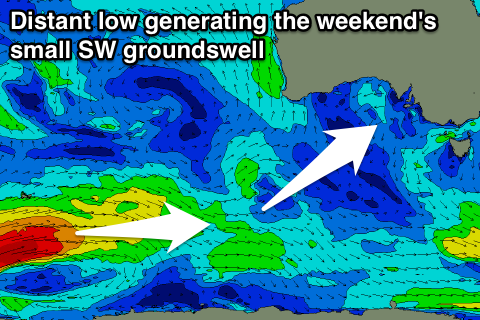
Into Saturday afternoon a small new SW groundswell is due, generated by a strong but distant polar low that's currently in the Heard Island region.
No major size is due off this low, with an increase to 2-3ft due at Middleton into the afternoon/evening, easing back from 2ft Sunday. Winds will improve further, tending light NE through the morning, so this will be the morning to surf on the weekend. The Mid Coast will remain tiny to flat.
Longer term we may see a new swell mid-next week, but more on this Wednesday.

