Small lacklustre swells
South Australian Forecast by Craig Brokensha (issued Friday 10th November)
Best Days: South Coast swell magnets Saturday morning, Monday morning, Tuesday morning
Recap
Lighter winds out of the east across the South Coast yesterday with plenty of leftover S/SW swell but conditions were still fairly average and only for keen surfers.
This morning the surf was smaller but cleaner and a new S/SW swell is on the build providing fun waves across exposed breaks.
The Mid Coast has been flat the last day and a bit, but a tiny W/SW swell should pulse to 1ft+ this afternoon.
This weekend and next week (Nov 11 - 17)
Today's building S/SW groundswell should reach a good 3ft off Middleton this afternoon though with developing sea breezes, while the Mid Coast should see that pulse of W/SW swell to 1ft+.
Both swells are expected to ease into tomorrow leaving dropping 2-3ft sets off Middleton at dawn and 1ft on the Mid Coast.
 Winds will be good for the swell magnets on the South Coast tomorrow with a moderate to fresh NE breeze, tending variable ahead of possible late sea breezes, while Sunday will play out similarly but with small to tiny leftovers.
Our new long-range and inconsistent W/SW groundswell for late Sunday and more so Monday is still on track with a strong but short-lived low firing up west-southwest of WA earlier in the week, generating inconsistent sets later Sunday to 1ft+ across the Mid Coast, holding Monday while Middleton should reach an infrequent 2ft on the sets.
Monday will be super clean with a light offshore breeze, tending variable ahead of late sea breezes.
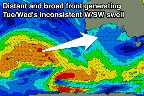
Into Tuesday and Wednesday a slightly better but still inconsistent W/SW groundswell is due, generated by a broader and more prolonged but weaker polar front developing on the tail of the mid-latitude low.
We should see Middleton continuing around an inconsistent 2ft on the sets, while the Mid Coast and 1-1.5ft on the favourable parts of the tide across the Mid Coast.
Winds will remain favourable for both coasts, with a dawn NE breeze, tending N'ly through the morning and NW into the afternoon on Tuesday, while a trough looks to move in from the west for Wednesday, bringing increasing onshore S/SW winds.
This trough will stall just to our south-east through the end of the week, directing strong S/SE winds into the South Coast and producing moderate amounts of junky S/SE windswell as the groundswell fades.
There'll be no new groundswell across the state until a possible small increase next weekend, but we'll have another look at this Monday. Have a great weekend!


Comments
Still a couple of baby waves on the Mid. Nice conditions though!