Cleaner conditions with smaller swell pulses
South Australian Forecast by Craig Brokensha (issued Wednesday 8th November)
Best Days: South Coast Thursday morning, Friday midday, Saturday morning, Monday morning
Recap
A continuation of poor surf yesterday with gusty onshore winds and a junky windswell across the South Coast, while the Mid was tiny through the morning, pulsing to 1ft or so into the afternoon.
This morning a strong new S/SW groundswell has peaked across the South Coast with 3-4ft sets across most breaks, but conditions were still average under a light E'ly wind. The Mid Coast dropped back to a near flat 0.5ft.
This week and weekend (Nov 9 - 12)
This morning's strong pulse of S/SW groundswell is expected to ease through today, dropping back further tomorrow as winds continue to improve. An E/NE-NE breeze will create much cleaner conditions across the South Coast during the morning, but it'll still be peaky. Middleton should ease back from 2ft to occasionally 3ft.
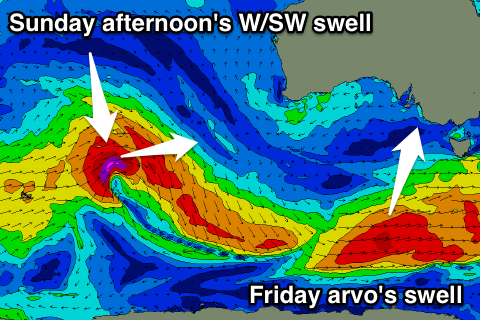
 A low point in swell is due early Friday, but a fun new S/SW groundswell is due to build through the day, generated by a strong polar front that's currently developed south-west of Tassie. This system isn't as strong as the one that generated this morning's swell but should still provide good 3ft sets across Middleton into the afternoon, easing back Saturday from 2-3ft.
The Mid Coast will be tiny through tomorrow, but a small W/SW swell is expected into Friday to 1ft+ on the favourable parts of the tide, generated by the initial stages of the polar front that's currently south of us.
Winds on Friday should be even better than Thursday with a NE-N/NE breeze through the morning, tending variable early afternoon before sea breezes kick in. So a midday/early afternoon surf will probably be best as the swell starts kicking down South.
NE winds will keep conditions clean into Saturday as the swell eases before sea breezes kick in.
Our next pulse of swell is due from the W/SW into Sunday afternoon and Monday morning, generated by a distant and strong but short-lived low firing up between WA and Heard Island today and tomorrow.
No major size is expected off this system, with the Mid Coast likely to build to 1ft+ through the day, while Middleton is only due to reach an inconsistent 1-2ft max, holding Monday.
Winds will remain favourable into early next week with warm-hot NE breezes but no major swell. Exposed breaks look the go early-mid week for small fun waves.

