Persistent onshore winds for Victor; long range has some hope
South Australian Surf Forecast by Ben Matson (issued Friday 3rd November)
Best Days: No great days in the short term due to poor local winds at Victor, and a lack of swell on the Mid. Aim for next Thurs/Fri/Sat when we'll see NE winds down south and a fun size for the open beaches.
Recap: Thursday offered great surf across both coasts, with light winds at Victor for much of the day and a solid 4-5ft groundswell at Middleton, bigger at exposed spots. The Mid Coast was a little inconsistent but managed some clean 2ft to almost 2-3ft sets throughout the day. Freshening S’ly winds through the afternoon at Victor have picked up across the Mid Coast this morning, and the swell has slowly easy with bumpy offerings down south and small slow waves in the gulf.

Thursday lunchtime at Middleton
This week and weekend (Nov 2nd onwards)
*today’s notes will be brief as Craig’s away*
The forecast period doesn’t offer a lot of hope.
We have no major groundswells on the cards and an extended, predominant SE airstream ahead, so with little swell potential for the Mid Coast we’ll have to pick the eyes out of the wind forecast at Victor.
Fortunately, there won’t be any shortage of swell. Today’s energy is easing but a series of fronts passing to the south will maintain average 2ft+ sets on Saturday, with a small bump for Sunday to 3ft originating from the second, stronger system.
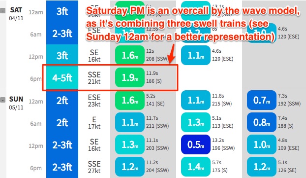
Quick note #1: the wave models have totally ballsed up the weekend height predictions, thanks to the presence of strong onshore winds - it’s combined all of the swell trains (distant, easing groundswell + local windswell + small new mid-range energy) into a single swell train (see below), which is massively overcalling the size on Saturday afternoon. But, this is a moot point anyway with the likely onshores.
Quick note #2: There’s some pretty major discrepancies in the wind forecast for Saturday too. Our surf model has SE 16kts tending S/SE 21kts from noon to 6pm Saturday (at Victor) but the high res wind models seem to suggest it’ll be a lot lighter. Not sure on the mechanics here (i.e. why our model is overestimating) but I suspect conditions may improve slightly after lunch as the wind temporarily abates. Only slightly though. Not worth a drive from the big smoke, anyway.
Winds may briefly swing lighter E/NE on Sunday morning too, but it’s unlikely to clean up the SE wobble from Saturday’s winds, to any great degree. However if you absolutely have to surf, keep an eye on the Hindmarsh Island and Parawa AWSs and pounce if you see average wind speeds under 10kts, and aim for a protected eastern end. It’s a low percentage game but the only one you have up your sleeve this weekend.
As for the next few days on the Mid, expect small residual but fading swells best suited to grommets and overly enthusiastic longboarders.
And, next week? A slow moving high pressure system south of the state will maintain a general SE flow all week, with pockets of (relatively) lighter E’ly winds in the early mornings. However the high will gradually move east and as it does will bring about a NE airstream - this is expected Thursday, Friday and Saturday. So, hold out until then for the best conditions down south.
We will also see a decent pulse of S’ly swell on Wednesday, originating from a strong polar front that will sneak through the eastern periphery of our swell window from late Sunday through Monday, S/SW of Tasmania. This will kick up a solid S/SW swell in the 3-4ft range by the afternoon, though with the SE flow conditions probably won’t be very good.
This swell will also be too south for the Mid Coast.
The Victor offshore pattern from Thursday onwards will be accompanied by easing swells best suited to exposed stretches, owing to the blocking pattern. But, there could be some very nice beachies on offer next Friday and Saturday (banks pending) - worth pencilling in I reckon. More on this in Monday’s update.


