Great weekend down South, good swells next week
South Australian Forecast by Craig Brokensha (issued Friday 8th September)
Best Days: South Coast all weekend, swell magnets Monday, South Coast Tuesday, Mid Coast Thursday
Recap
Average onshore waves across the Mid Coast to 1-2ft on the favourable parts of the tide, back to a tiny 1ft today with easing onshore winds, variable now.
The South Coast saw solid levels of S/SW groundswell hanging in at 3-5ft yesterday morning with a period of favourable winds.
This morning some new close-range S/SW swell from a cold front clipping us has kept the size up but conditions are fairly average.
This week and weekend (Sep 9 - 15)
Today's close-range S/SW swell will ease into tomorrow, only to be replaced by some stronger long-period energy, generated by the initial stages of the frontal system mid-week (that being a tight and intense polar low). We should see inconsistent but good 3-4ft sets hanging in across Middleton tomorrow morning, easing back through the afternoon, down more rapidly from the 3ft range Sunday.
The Mid Coast is expected to become tiny to flat with the unfavourable southerly swell direction.
Conditions look good tomorrow with a variable tending light offshore wind ahead of relatively weak sea breezes. Sunday will then see moderate to fresh N/NE tending lighter N/NW winds creating great waves all day.
 The swell will bottom out Monday, but the South Coast swell magnets will still see fun 2-3ft sets as a SW swell from unfavourably aligned pre-frontal NW winds south-west of WA. Conditions will be great with a N/NW tending W/NW breeze.
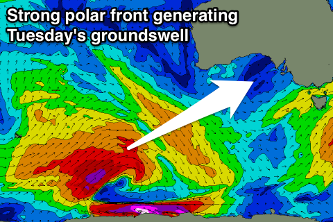
Of greater significance is the SW groundswell behind it, generated by a strong polar low. A broad fetch of gale to severe-gale W/SW winds will be produced, weakening slowly as the system moves east towards us.
We should see a moderate sized SW groundswell produced, filling in overnight Monday and peaking Tuesday to a strong 3-4ft across Middleton. The Mid Coast should see infrequent 1-1.5ft sets on the favourable parts of the tide. Conditions look great again with NW offshores ahead of possible late change, with the change proper moving through Wednesday.
This change will be linked to a strong mid-latitude front pushing in from the west, bringing a new moderate to large sized W/SW groundswell for Thursday. The front moving ahead of the swell will bring an increase in windswell across the Mid Coast Wednesday in the 2ft range, but with poor W/SW winds.
We may see a ridge of high pressure moving in Thursday as the swell peaks, bringing lighter winds, but we'll have to review this Monday as the models aren't in alignment. Have a great weekend!

