Large messy surf, much cleaner over the weekend
South Australian Forecast by Craig Brokensha (issued Monday 4th September)
Best Days: Protected spots for keen surfers tomorrow down South, Wednesday morning around Victor and similar Thursday morning, South Coast all weekend
Recap
Great conditions across the South Coast Saturday but only small to tiny, best at Waits and Parsons. The Mid Coast was also tiny and clean with a slight lift in size through the afternoon.
Semi-stormy surf developed across the Mid Coast through yesterday while the South Coast started small and clean in protected spots ahead of some new swell building through the afternoon.
Today the Mid Coast continued around a stormy 3ft, a bit under expectations with the polar frontal system pushing into us sitting just a little further south than forecast on Friday. The South Coast was moderate is size this morning and OK in protected spots, but the swell has since continued to increase though with strong W/SW winds.
This week (Sep 5 - 8)
Our current episode of cold windy weather is due to a flurry of polar frontal activity being projected up and into us under the influence of a strong pronounced node of the Long Wave Trough sitting across south-east Australia.
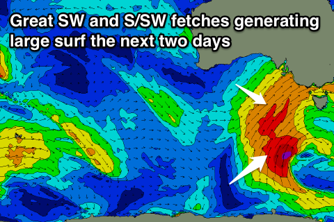
The swell is mainly from the W/SW currently, but we'll see some better aligned and larger SW swell filling in through tomorrow, generated by a great fetch of SW winds being projected towards us last night and today.
We should see exposed breaks reaching 8ft on the sets into the afternoon while the Mid Coast looks to continue around the messy 3ft range.
Strong W/SW winds will create average conditions across all locations, with the chance of a W'ly wind around Victor being slim. Protected spots will be best.
 Tuesday's late increase in S/SW groundswell has been shifted to Wednesday, with a polar fetch of gale to severe-gale S/SW winds expected to be projected up through our southern swell window through this afternoon and tomorrow.
This will see large levels of S/SW swell continuing most of the day down South, coming in around 8ft on the sets at exposed breaks most of Wednesday before easing late and down further from the 4-5ft+ range Thursday morning.
The Mid Coast should ease back from a smaller 2ft to occasionally 3ft Wednesday, down from 1-2ft Thursday.
Winds will remain onshore and fresh from the W/SW into Wednesday, though there's a greater chance for a W'ly breeze during the morning around Victor.
Thursday should see morning W/NW winds as another vigorous polar front approaches Victoria, swinging onshore into the afternoon from the W/SW to S/SW.
This front will project a quick burst of severe-gale to storm-force S/SW winds through our southern swell window, producing a moderate to large S/SW swell for Friday in the 6ft range down South, but it'll be too south for the Mid with tiny 1ft waves expected.
Winds will remain average and onshore from the S/SW though possibly tending light and variable during the day, with light S/SE offshores on the Mid Coast.
Looking into the weekend we'll see the S/SW groundswell easing mixed in with some background S/SW groundswell as winds swing offshore for the South Coast Saturday and freshen from the N'th Sunday, creating excellent conditions.
Longer term we're looking at some great W/SW groundswell from Tuesday next week, but more on this Wednesday.

