Fun west swells for the South Coast
South Australian Forecast by Craig Brokensha (issued Friday 11th August)
Best Days: South Coast Saturday and Sunday morning, protected spots South Coast Tuesday through Thursday
Recap
Tiny waves across the South Coast yesterday while the Mid Coast saw a building onshore windswell into the afternoon, though with no quality.
This morning the swell was a messier 2ft across the Mid Coast with a building W/SW swell, while the South Coast was only small with 2ft sets max off Middleton, but a further increase has been seen through this afternoon. Winds are gusty from the W/NW, favouring Middleton over most other breaks.
This weekend and next week (Aug 12- 18)
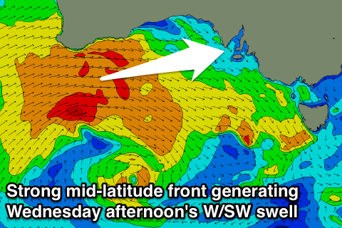
Yesterday and this morning a strong mid-latitude front moved through our western swell window, generating a moderate sized W/SW swell that is currently building across the state.
We should see Middleton reaching 4ft by dark today with 2-3ft sets on the Mid Coast under strengthening W/NW winds.
The secondary front that was expected to generate an additional pulse of swell tomorrow is now not looking as good, with it being weaker and producing less favourable W/NW winds.
What we're expected to see is 3-4ft waves off Middleton tomorrow morning, easing through the day, with easing 2ft sets on the Mid Coast.
Sunday will then be smaller with fading 1ft waves across the Mid Coast and easing 2-3ft sets off Middleton.
Conditions over the weekend will be great across the South Coast with a NW tending N/NW breeze tomorrow and N/NW winds all day Sunday.
The swell will bottom out across the South Coast Monday as winds persist from the N/NW while the Mid Coast should see a hint of new W/SW swell.
As touched on last update, tricky W/SW swell dominate early next week, with a strong broad stalling low south-west of WA, aiming varying fetches of gale to severe-gale W/SW winds through our western swell window.
 Monday's smallest swell will be generated by a burst of gale to severe-gale W'ly winds in the Mid Coast's swell window today, with infrequent 1-1.5ft sets due, possibly reaching 2ft with the right tide.
The best fetch looks to develop tomorrow evening with a stationary fetch of severe-gales being aimed towards us, generating a long-period W/SW groundswell for Tuesday morning.
This looks to be more in the 2ft range across the Mid Coast, with Middleton likely to see inconsistent 2-3ft waves. Winds will remain favourable for the South Coast though with a fresh and gusty NW tending stronger W/NW breeze.
From here, the mid-latitude low will push east towards us, generating a fetch of strong to gale-force W/SW winds through our western swell window, pushing across us Wednesday, followed by a secondary front Thursday.
Messy 3ft waves should develop into Wednesday afternoon across the Mid Coast, with stormy 4ft surf Thursday along with strong to gale-force W'ly winds, while the South Coast should build through Wednesday to 3-4ft, easing from a similar size Thursday.
With the W'ly winds, protected spots down South will be best, but more on this Monday. Have a great weekend!

