Lots of swell from Friday with improving winds over the weekend
South Australian Forecast by Craig Brokensha (issued Wednesday 12th July)
Best Days: Friday morning protected spots South Coast, Mid Coast keen surfers into the afternoon, both coasts Saturday, South Coast Sunday morning and early Monday
Recap
Tiny waves across the Mid Coast to 0.5-1ft yesterday morning, but the new swell saw sets hitting above 1ft into the afternoon as winds tended variable. The swell backed off to 0.5-1ft this morning along with average conditions.
The South Coast saw great waves yesterday with the new SW groundswell coming in at 3-4ft off Middleton. Morning offshores tending variable as well, keeping conditions favourable into the afternoon. Today the swell was smaller but clean again with freshening offshores.
This week and weekend (Jul 13 – 16)
 Tomorrow is worth giving a miss as today's swell continues to ease leaving small to tiny surf down South with a fresh to strong N/NW tending NW breeze. This is likely to kick up an increase in NW windswell across the Mid Coast to 1-1.5ft through the day.
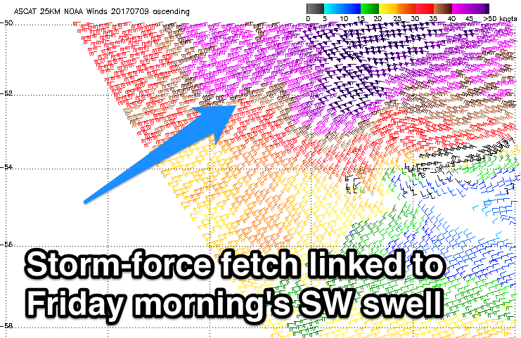
Later in the day we should see a few new long-period sets appearing across the South Coast, linked to a new SW groundswell due Friday. This swell was generated by a vigorous polar front earlier this week, producing a fetch of severe-gale to storm-force W'ly winds in our far western swell window.
A peak is expected Friday morning to an inconsistent 3ft+ across Middleton with 4ft sets towards Cliffs and Goolwa.
The swell will ease temporarily into the afternoon ahead of a large and powerful W/SW groundswell kicking later in the day ahead of a peak Saturday morning.
After the vigorous polar front responsible for Friday morning's swell weakened, a broader and more significant polar front fired up in its tail, projecting a fetch of severe-gale W/SW winds up towards WA and through our western swell window.
The front was weakened and is positioned south-west of WA while continuing to generate a broad fetch of strong W/SW winds.
 We'll see this front move east through the Bight tomorrow, passing across us Friday.
What will result is a mix of large long-period W/SW groundswell and mid-period W/SW swell for later Friday and Saturday.
The Mid Coast should build from the 2ft+ range to 3ft+ into the afternoon but with fresh to strong W/SW winds. Easing surf is then due from the 2-3ft range Saturday as a possibly dawn onshore tends variable. This will create fun lumpy waves for keen surfers.
The South Coast should see morning W/NW winds on Friday, giving into the W/SW change as the swell builds later.
A peak is expected Saturday morning to 4-5ft across Middleton and winds should swing W/NW after dawn and persist all day.
The swell will ease steadily through Sunday but conditions will be excellent with fresh and gusty N/NW winds.
Into early next week the Mid Coast is expected to see another solid pulse of W/SW groundswell, generated by a strong and slow moving mid-latitude low in from the west over the weekend.
It looks to come with a lot of wind on Monday, while the South Coast looks clean Monday morning ahead of a strong onshore change. More on this Friday.

