Fun week across the South Coast, larger and messier late week
South Australian Forecast by Craig Brokensha (issued Monday 10th July)
Best Days: South Coast Tuesday and Wednesday morning, protected spots Friday morning South Coast, South Coast Saturday morning and Sunday morning
Recap
Poor conditions across the Mid Coast with choppy waves to 1-2ft Saturday, back to a lumpy and tiny 1-1.5ft on Sunday.
The South Coast offered fun clean small waves Saturday, with better options Sunday due to a new inconsistent SW groundswell filling in.
This morning this swell was back to 2-3ft with clean conditions but we should see a new mid-period SW swell kicking later today, peaking tomorrow (discussed in more detail below).
This week and weekend (Jul 11 – 16)
This afternoon's increase in mid-period SW swell was generated over the weekend and early this morning by a broad but relatively weak polar front projecting towards Victoria.
The swell is due late in the day, peaking tomorrow morning to 3-4ft across Middleton, easing back into the afternoon and down further from 2ft to occasionally 3ft Wednesday morning.
The Mid Coast is due to remain tiny with 1ft+ sets tomorrow, smaller Wednesday.
 Conditions look great tomorrow with a light N/NW tending variable breeze, and then fresh N'ly winds Wednesday.
A low point in swell is due Thursday morning with gusty N/NW winds, while later in the day we may see a new long-period SW groundswell filling in.
Currently a strong front is generating a fetch of severe-gale to storm-force W'ly winds in our south-western swell window, but will push east closer to us today before weakening early tomorrow.
An inconsistent long-period SW groundswell will head towards us, arriving late Thursday, building to 2ft+ across Middleton ahead of a peak Friday morning to 3ft+.
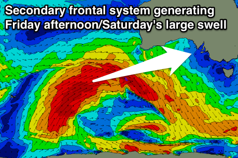
Of greater significance is a secondary broader frontal system generating a fetch of severe-gale W/SW winds while projecting up towards WA, and then through the Bight late week.
This will generate a large and powerful W/SW groundswell for Friday afternoon and Saturday morning, with some stormy localised W/SW windswell in the mix across the Mid Coast.
We should see messy surf building from 2ft to 3ft into Friday afternoon on the Mid with fresh to strong W/SW tending SW winds, while the South Coast is due to build further to 4-5ft later in the day at Middleton.
The groundswell is expected to slowly ease through Saturday but Middleton will still be solid with 3-5ft sets, and the Mid Coast in the 2ft+ range.
Protected spots are looking best with a morning W/NW breeze, swinging onshore into the afternoon, with stronger offshore N/NW winds Sunday from an approaching front as the swell continues to ease.
Another W/SW swell is likely early next week behind the front bringing Sunday's strengthening winds, but more on this Wednesday.


Comments
26-29th solid swells for oz 'n' mentawais?