Great Saturday, stormy swells for next week
South Australian Forecast by Craig Brokensha (issued Friday 30th June)
Best Days: Saturday South Coast, stormy options Monday afternoon on the Mid Coast, protected spots Monday and Tuesday mornings South Coast, Wednesday South Coast
Recap
Poor conditions across the South Coast yesterday with an onshore change and no lack of swell. Winds did improve later offering some OK waves in Middleton Bay for keen surfers. The Mid Coast was tiny, but built a little into the afternoon to 1-1.5ft.
Today winds tended light offshore down South but there was lots of lumpiness to the swell from overnight onshores. The size was still up and the waves have improved into the late morning. The Mid Coast was clean but tiny again with 1ft teasers.
This weekend and next week (Jul 1 - 7)
Tomorrow should be excellent if not a little windy across the South Coast as an approaching front brings fresh and gusty N'ly winds. Middleton should be easing from 3ft with larger waves at Waits and Parsons, while the Mid Coast will be tiny with a weak N'ly windswell.
The small SW groundswell for Sunday is looking a bit hit and miss now, with the pre-frontal fetch being too NW to generate any real size. We're likely to see small 1-2ft waves down across Middleton with stronger and average N/NE winds.
These winds should kick up a small N/NW windswell across the Mid Coast through the day, building to 1-2ft into the afternoon.
Our strong W/SW groundswell for Monday is still on track, with a vigorous polar frontal progression projecting towards WA yesterday and today. The system is a touch weaker than forecast on Wednesday and as such there's been a slight downgrade in size, mainly for the South Coast.
 A fetch of gale to severe-gale W/SW winds are being generated through our western swell window, and we'll see the W/SW groundswell coming in at 2-3ft across the Mid Coast, while the South Coast should see 3-4ft sets off Middleton
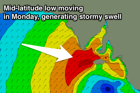
The remnants of the storm generating the W/SW groundswell are still expected to form into a mid-latitude low across the south of the country and we'll see this low move in and across us through Monday.
With this a fetch of strong W/NW tending W/SW winds will be seen across both regions, kicking up a stormy windswell across the Mid Coast in the 3ft+ range through the afternoon.
The low will weaken into Tuesday and with this we'll see a mix of easing W/SW groundswell and SW windswell from a similar size to Monday down South with easing 2ft sets on the Mid Coast.
A morning W/NW breeze should create OK conditions in protected locations down South Tuesday morning, with better offshores.
Into later Wednesday and Thursday morning an inconsistent SW groundswell is due, produced by a very strong but tight polar low that's currently in the Heard Island region.
This swell will be inconsistent but good with a peak due Thursday morning to 3-4ft at Middleton. The Mid Coast isn't likely to see much size with a tiny 1ft of groundswell, but a mid-latitude low approaching through the Bight may kick up some bigger windswell.
This mid-low is likely to generate an acute and large stormy W/SW swell for late next week, followed by a larger SW swell over the weekend, but more on this Monday. Have a great weekend!

