Pumping Tuesday and Friday, with windows in between
South Australian Forecast by Craig Brokensha (issued Monday 26th June)
Best Days: South Coast Tuesday and protected spots Wednesday morning, Friday, Saturday, Sunday both coasts (bumpy Mid)
Recap
Well what a swell event! Overnight Friday and Saturday morning the Cape du Couedic wave buoy rocketed northwards, recording 5m+ of pure S/SW groundswell at 18 seconds.
This equated to maxing surf across the South Coast, closing out even the deepest channels, with novelty spots providing OK waves. Bullies was maxing and only for the most experienced with large lumpy sets unloading on the outside reef.
The swell was too south for the Mid Coast but still provided 1-1.5ft sets, holding into yesterday before becoming tiny today.
Yesterday was the day to surf down South with pumping clean offshore surf easing from the 4-6ft range while today was good again with a reinforcing S/SW swell.
This week (Jun 27 – 30)
Today's S/SW groundswell was generated by a broad and expansive but not overly strong polar front pushing up towards Victoria yesterday.
A secondary front generating a fetch of trailing W/SW winds south of us last night and into early this morning will produced a reinforcing S/SW swell for tomorrow.
We should see Middleton persisting at 4ft tomorrow morning, easing later in the day and then easing back from 3ft Wednesday morning.
 The Mid Coast won't see any decent size with the odd 0.5-1ft set tomorrow, 0.5ft Wednesday.
Conditions look excellent tomorrow with a light offshore N/NE tending NW breeze, while Wednesday morning will see a W/NW offshore, giving into a S/SW change early-mid afternoon.
This change will be linked to another polar front projecting towards us, weakening as it does os.
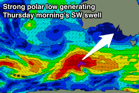
This system is currently forming south of WA, generating a great fetch of severe-gale W/SW winds while projecting north-west towards Victoria.
A moderate sized SW groundswell will be generated, possibly showing late Wednesday but peaking Thursday to 3-5ft across Middleton. The Mid Coast is due to see tiny 1ft waves, but bumpy conditions will create average conditions for beginners.
This swell will reinforced by a secondary mid-period S/SW swell later in the day and Friday morning, produced by a secondary fetch of strong S/SW winds projecting into us Thursday, but moving off quickly to the east Friday.
With this we'll see early W'ly winds swinging fresh S/SW Thursday, but then a return to offshore N'ly winds Friday as the swell comes in around 4-5ft across Middleton, but still tiny on the Mid.
This weekend onwards (Jul 1 onwards)
Saturday and Sunday look great down South with fresh offshore N'ly winds linked to a vigorous mid-latitude frontal progression approaching from the west. The swell will be on the ease Saturday, with some good new W/SW groundswell from the progression arriving into Sunday and easing Monday.
At this stage we're looking at a broad and expansive fetch of gale to severe-gale W/SW winds projected from the south-west of WA, through the bight, generating a moderate to large sized W/SW groundswell.
Winds for the Mid Coast aren't ideal, while the South Coast looks best, but we'll have another look at the winds and size (likely 2ft to occ 3ft Mid Coast) on Wednesday.

