Large powerful S/SW groundswell with light winds
South Australian Forecast by Craig Brokensha (issued Friday 23rd June)
Best Days: Experienced surfers South Coast Saturday and Sunday morning, Monday morning South Coast, Tuesday South Coast, beginners Mid Coast Saturday
Recap
Pumping waves down South with solid amounts of swell and offshore winds most of the day, while the Mid Coast backed off to a tiny 0.5-1ft.
This morning we've seen the swell reach a low point with 0.5ft waves on the Mid and clean 2-3ft waves across Middleton down South.
This weekend and next week (Jun 24 – 30)
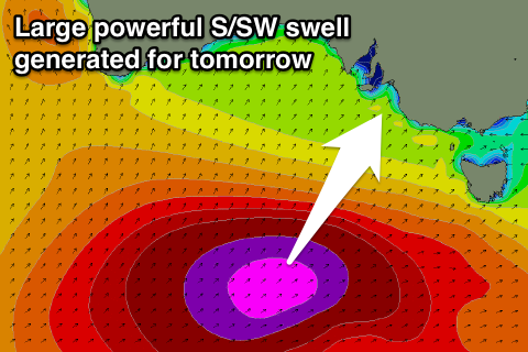
We've got some great satellite observations of the vigorous polar frontal system that's currently projecting up towards Victoria, on top of an already active sea state.
50kt barbs have been observed, and the progression will continue generating severe-gale W/SW winds through our southern swell window today before moving across Tassie this afternoon and evening.
A large, powerful, long-period S/SW groundswell will result, peaking mid-morning/midday tomorrow. The South Coast should see large powerful sets to 8ft, with the odd bigger bomb likely at deep water reefs and offshore bommies.
 The swell will be too south for the Mid Coast to see any major size, but in saying this 1-1.5ft sets are likely to squeak in all day.
Now, looking at the local winds and we've got a tricky and less than ideal setup due through tomorrow.
A weakening trough will linger just to our west and with this we're due to see light E'ly tending E/NE winds across both coasts through the morning, tending SE into the afternoon. This won't create epic conditions but with the strength of the swell and light winds, select breaks should still be really good.
Sunday looks good in protected spots with a morning W/NW breeze, tending W/SW into the afternoon as the swell eases back from the 4-6ft range off Middleton and other swell magnets.
The Mid Coast is due to be tiny and easing from 1ft.
Into Monday a good sized S/SW groundswell is due across the South Coast again, produced by a weaker but broad polar front projecting towards us over the weekend.
Wind strengths aren't due to really get above the strong to gale-force range, but sizey sets to 4-5ft are due to develop across Middleton through the day. Tuesday morning will continue to provide plenty of size due to the longevity of the polar S/SW fetch, with easing surf from a similar 4-5ft.
The Mid Coast will should see the odd 1ft set, but that's about it both Monday and Tuesday.
Winds Monday are looking more variable than anything creating OK conditions down South, but Tuesday looks excellent with a light offshore N/NE tending variable breeze.
There's moderate pulses of S/SW swell on the cards for late week, but winds look average in the wake of a change Wednesday. More on this Monday. Have a great weekend!


Comments
We wouldnt have to blow up k.i ...just tow it out a little...
http://www.transport.wa.gov.au/imarine/esperance-tide-and-wave.asp
Ssw swell arriving at esperance.
Tassie :
http://www.bom.gov.au/products/IDT65014.shtml
This morning there is swell bigger , cleaner , longer , thicker etc , Than ive seen before .
Very amazing to say the least ,
Its huge and violent along the cliffs here
Epic Clam!!!
5m of pure S/SW groundswell at 18s!
That unblocked south direction compared to big wests (blocked a little) is why you'd be seeing so much size I reckon.
Less "attenuation due to bottom friction" craig ?
Maybe , its because in the past i went elsewhere on days like today & didnt see the cliff . That could be why also .
Hilarious to see this reported as 4ft on Saturday morning.
4ft Hawaiian brah
Fraser Gordon you have a dig this day ?
Think he's been in Indo.
Yes checked vglgfg