Fun week down South, large powerful swell this weekend
South Australian Forecast by Craig Brokensha (issued Monday 19th June)
Best Days: Every day South Coast, tiny for the most part on the Mid Coast
Recap
A bit more size than expected across the Mid Coast over the weekend and even into today. The surf has hung around 1-2ft with reinforcing W/SW pulses keeping small fun waves hitting the region.
The South Coast has been pumping with clean easing surf from 3-4ft Saturday morning, coming in around 3ft yesterday morning ahead of a strong pulse in new S/SW swells with weak onshore winds. This morning we've got excellent conditions again with easing surf from the 3-4ft range off Middleton.
This week and weekend (Jun 20 – 25)
Our current mix of swells breaking across both coasts should ease back into tomorrow, with fading 1ft surf on the Mid Coast and easing sets from the 3ft range off Middleton.
Conditions will be excellent down South with a moderate to fresh N/NW breeze, easing and tending lighter W/NW into the afternoon. The Mid will be OK at dawn with an early N/NE breeze.
A shallow overnight change will clear by Wednesday morning leaving light variable (tending locally offshore winds). This change will be linked to a strengthening polar front projecting up towards us today and tomorrow, producing a fetch of strong to gale-force SW winds in our southern swell window.
 We should see a moderate sized S/SW groundswell generated by this fetch, building through Wednesday and holding Thursday.
Middleton is due to be around 2-3ft early, building to 3-5ft later in the day and holding in the 4ft range Thursday before easing Friday.
The swell will be too south for the Mid Coast with tiny 1ft surf due later Wednesday and Thursday.
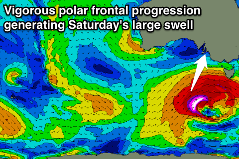
As talked about last update, we've got the first real serious winter frontal progression this winter forecast to develop later this week in the Indian Ocean.
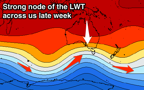
 This will be the result of a node of the Long Wave Trough strengthening over the south-east of the country later this week, feeding and steering a vigorous polar front right up and through our southern swell window.
An initial strong polar front will generate a fetch of pre and post-frontal W/NW to W/SW gales, creating an active sea state for a secondary much stronger and broader front to move over. This secondary front will project a fetch of severe-gale to storm-force SW winds towards the south-east of the country, with a large long-period S/SW groundswell being generate for Saturday.
At this stage we're looking at large surf in the 8ft range across exposed breaks down South and 1-1.5ft waves on the Mid Coast.
We're hopefully looking at variable winds Saturday, creating clean conditions, then NW to SW breezes Sunday as the swell eases. We'll have a closer look at the expected size and winds on Wednesday though.

