Further strong swells for the Mid Coast
South Australian Forecast by Craig Brokensha (issued Monday 6th June)
Best Days: Mid Coast Tuesday, South Coast Wednesday, Friday Mid Coast, Saturday both coasts, Sunday South Coast
Recap
Tiny waves Saturday on the Mid Coast, but the new W/SW groundswell filled in nicely yesterday with clean 2ft sets, bigger into the afternoon. The South Coast was small and clean Saturday, best at Waits and Parsons, similar Sunday but bigger into the afternoon as the W/SW swell filled in.
Today the swell is building towards a peak with strong 2-3ft sets on the Mid this morning with variable winds, while the South Coast was seeing some better size with clean 3ft waves off Middleton under perfect offshore winds.
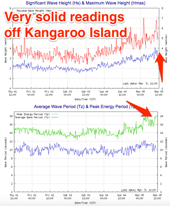
The Cape du Couedic wave buoy is showing some impressive numbers with Maximum Wave Heights hovering between 3.5-4m at peak periods of 16-18s. Ben had the swell peaking this afternoon to 3ft+ on the sets across the Mid Coast and 4-5ft off Middleton and this looks on target. The image below shows plenty of size currently.

This week and weekend (Jun 6 – 11)
 While today's strong W/SW groundswell is due to to peak this afternoon/evening, we'll see a reinforcing mid-period SW swell from a front currently passing under us today.
This will see the Mid Coast easing from 2ft+, while the South Coast should still see 3-4ft waves off Middleton but S'ly winds will create poor conditions. The Mid should see S/SE breezes, creating fun conditions.
Wednesday will be fun down South as winds swing back offshore from the N'th, tending NW into the afternoon with easing 3ft+ sets off Middleton. The Mid Coast is likely to be back to the 1-1.5ft range.
A low point in swell is expected Thursday morning and an approaching front will swing winds from an early W/NW'ly around to the S'th through the morning. It won't be worth the drive South from Adelaide though.
Later in the day though a strong new W/SW groundswell is expected, generated by the front passing through during the day.
This front is currently in the form of an intense low in the Heard Island region, with a fetch of severe-gale to storm-force W/SW winds being generated through our western swell window.
We'll see this low project up towards WA and then east-southeast under the Bight over the coming days, leaving a moderate to large W/SW groundswell in its wake.
 This swell may be seen late in the day Thursday on the Mid Coast, but a peak is due Friday (through the middle of the day/afternoon) to 2-3ft (if not for the odd bigger sneaker) while the South Coast should build to an inconsistent 3-5ft off Middleton.
Winds are dicey in the wake of Thursday's change with onshore S/SW tending S/SE winds down South, but the Mid Coast should offer SE tending S'ly breezes.
Easing surf is expected through the weekend but conditions will improve down South with a NE breeze Saturday morning and N/NE winds Sunday morning as a large high moves in from the west.
This high will result in persistent NE winds across the region along with smaller more distant and inconsistent swell energy, but more on this Wednesday.


Comments
Still sets on dawn this morning..
Plenty of waves late yesty too. No-one out either!