Lots of swell to come, but you'll have to work the winds
South Australian Forecast by Craig Brokensha (issued Friday 26th May)
Best Days: South Coast Saturday (Mid Coast early), protected spots down South Sunday morning, all day Monday down South
Recap
Better conditions across the Mid Coast yesterday but only around 1-1.5ft through the morning, kicking to 1-2ft with the incoming tide. The South Coast was super fun with good clean waves off Middleton.
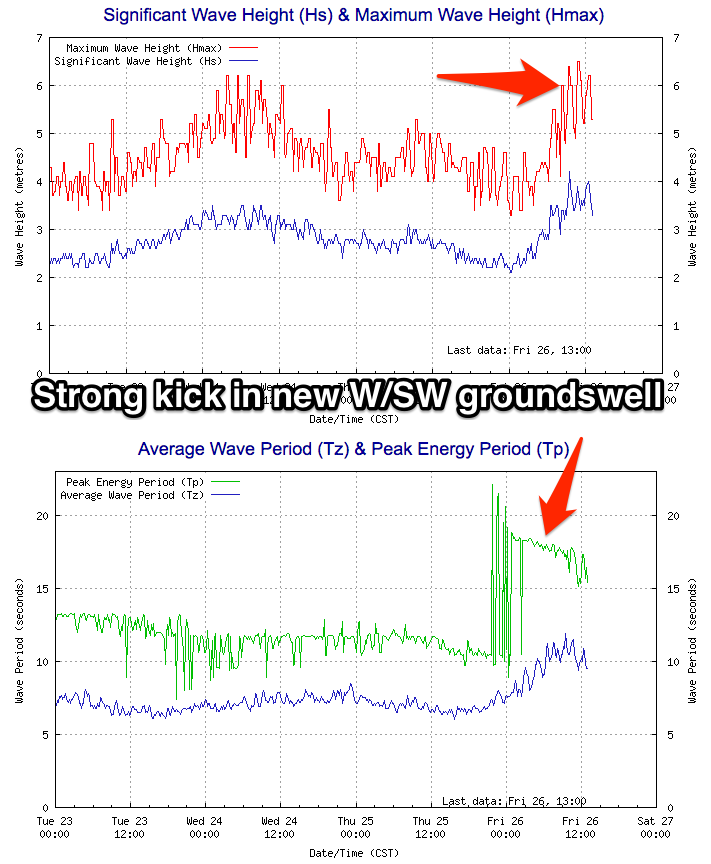
This morning the swell was back to 1-1.5ft on the Mid Coast but our strong new W/SW groundswell is kicking on the Cape du Couedic wave buoy and the Mid Coast is now seeing 2ft sets with a northerly wind. We should see a few bigger ones in the mix as the tide fills in this afternoon but it'll get full on high.


The South Coast was clean and around a similar size to yesterday, but the new swell has since built and conditions are great.
This weekend and next week (May 27 – Jun 2)
 Today's building W/SW groundswell should peak this evening and ease off steadily through the day. The Middleton stretch should see 3-5ft sets during the morning with easing 2ft sets on the Mid with a fresh N/NW tending W/NW breeze. The Mid will probably see N/NE winds at dawn creating clean conditions.
This wind change will be related to a vigorous mid-latitude frontal system moving in from the west.
Currently south of WA a strong mid-latitude front is deepening, and we'll see a fetch of W/SW gales projected through our south-western swell window through today and tomorrow, before the system weakens south of us Sunday.
A moderate to large SW groundswell should be produced for Sunday, peaking through the late morning/middle of the day.
We should see the South Coast offering 4-5ft+ waves off Middleton, with 2-3ft sets on the Mid Coast.
Winds are now due to be a touch weaker so the Mid won't be full blown stormy, and just messy with a fresh and gusty W/SW breeze. The South Coast should see a morning W/NW breeze before shifting W/SW mid-late morning.
The swell is expected to ease back through Monday and the South Coast will be best with W/NW winds due to persist all day. The Mid Coast will remain bumpy and average, with easing surf from the 2ft range.
Into Tuesday the swell should continue to ease, and there's a chance for an early N/NW offshore ahead of a strong S/SW change during the morning.
The models are moving around regarding the strength, timing and also the extent of this front, with the latest updates turning it more into a trough rather than a strong frontal progression.
With this we'll only see a poor increase in S/SW windswell through Tuesday afternoon, easing Wednesday with easing S/SE winds.
Some distant SW groundswell will also be in the mix, generated by a good pre-frontal fetch of W/NW gales through the southern Indian Ocean, but this will be hard to discern under the windswell.
Longer term the swell will ease under offshore winds Thursday and Friday mornings, with some new swell possible next weekend, but more on this Monday. Have a great weekend!

