Improving waves Friday, small clean weekend with more action next week
South Australian Forecast by Craig Brokensha (issued Wednesday 17th May)
Best Days: Friday late morning onwards down South, Saturday morning, Tuesday next week onwards
Recap
Flat across the Mid Coast yesterday, while a tiny N'ly windswell was seen pushing down the gulf this morning.
The South Coast was small yesterday morning with OK NE winds, while the afternoon saw lighter breezes and better conditions with a new inconsistent S/SW swell. This swell has backed off to 2ft this morning across Middleton but conditions were excellent with a fresh and straight offshore wind.
This week and weekend (May 18 – 21)
Give tomorrow a miss as this morning's S/SW swell will continue to ease leaving tiny waves under E/NE-NE winds. The Mid Coast will become flat with the windswell backing off later today.
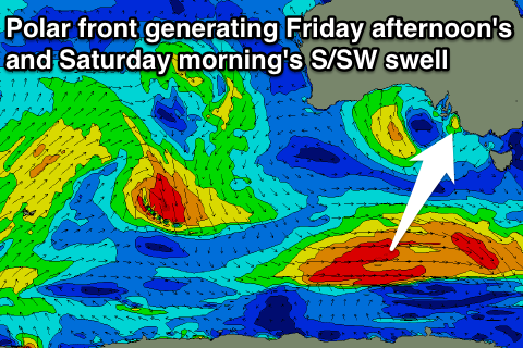
Our new S/SW groundswell for Friday has been upgraded a little with the late forming polar front linked to the swell being a touch stronger than forecast on Monday.
 We'll see a great fetch of W/SW gales projected through our southern swell window today, with the swell building Friday and reaching 3ft into the afternoon across Middleton (smaller early).
This swell should then ease back through Saturday from 2ft off Middleton (if not for the odd bigger one at dawn).
Conditions look a little dicey Friday morning with a possible early E/SE breeze, but a more variable wind should develop through the day as the swell builds.
Saturday morning looks best with freshening N/NW tending W/NW winds into the afternoon as the swell eases.
Sunday will be clean again but there'll be hardly any swell left at all on the coast, with Waits and Parsons being the only real option.
Next week onwards (May 22 onwards)
We'll start to see some new W/SW swell energy into next week as another mid-latitude low and following fronts move in from the west, directing better aligned fetches under WA and through the Bight from Sunday through most of next week.
Winds look to be in the strong to gale-force range with multiple back to back pulses of W/SW swell due from Monday afternoon through the rest of next week.
The models are still moving around regarding the timing and sizes of each pulse but it looks like we'll see winds from the north-west quadrant favouring the South Coast, while the Mid will see plenty of surf but bumpy conditions. We'll have another look at this Friday though.

