Small and offshore
South Australian Forecast by Craig Brokensha (issued Monday 15th May)
Best Days: Tuesday afternoon and Wednesday down South, Saturday and Sunday at swell magnets down South
Recap
Tiny fading waves across the Mid Coast, back from 1ft Saturday and near flat Sunday.
The South Coast was OK Saturday with variable winds and wobbly workable waves that like east winds, similar but smaller Sunday.
Today was cleaner but small and best at Waits and Parsons.
This week and weekend (May 16 – 21)
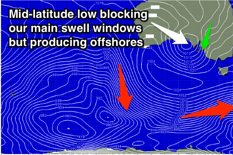
As talked about the last few updates, this coming period will be dominated by a broad mid-latitude low slowly moving in from the west, stalling while weakening in the Bight, only to be replaced by a secondary similar low later in the weekend.
These lows will firstly block our main swell windows, with us having to rely on frontal systems deflected around the boundary of this low, while also sitting too high to generate any decent W'ly swell for the Mid Coast. A lose lose situation.
The one winner though is the South Coast, with conditions expected to be favourable through the whole period besides Friday.
Offshore and sometimes strong NE-N/NE winds are due to persist the coming days with a small bump in S/SW groundswell tomorrow and Wednesday.
This swell, generated the last couple of days by polar W/NW gales should provide inconsistent 2ft to occasionally 3ft sets off Middleton into tomorrow afternoon, easing back from 2ft Wednesday morning.
 Thursday and Friday look average with small to tiny waves on the former with NE tending E/NE winds, and then E/NE tending SE winds Friday with tiny waves early, increasing slightly through the afternoon with a small new S/SW swell.
This swell will be generated by a late forming polar frontal progression south of us Tuesday evening, and only a small increase to 2ft is again due across Middleton, holding Saturday morning.
Our models are showing a kick in size later Saturday but we're more likely to see the swell remaining steady all day, with a long-range and very inconsistent long-period SW swell incorrectly being added to the easing S/SW swell.
Winds will swing N/NW into Saturday with the new approaching mid-latitude low from the west, persisting from the N/NE Sunday with small fading surf.
The Mid Coast isn't expected to see any size at all this week with the low sitting too far north and any west fetches being blocked by the Eyre Peninsula.
Moving into next week though, the secondary mid-latitude low is forecast to move in and across us early next week, bringing an increase in W/SW swell, but more on this Wednesday.

