Good W/SW groundswell tomorrow with light winds
South Australian Forecast by Craig Brokensha (issued Wednesday 10th May)
Best Days: Both coasts Thursday and Friday morning, South Coast from the weeend
Recap
Tiny easing waves on the Mid Coast yesterday, effectively flat this morning.
The South Coast was clean and fun yesterday morning, while this morning the waves were smaller and best at Waits and Parsons.
This week and weekend (May 11 – 14)
The first sign of our strong long-range W/SW groundswell has just hit Cape du Couedic, with the wave buoy seeing peak periods jumping to 18 seconds (below).

This is the long-period fore-runners which don't have any major size attached to them with the bulk of the swell being in the 16-17s range, filling in tomorrow.
This swell, generated by a vigorous polar frontal progression through the southern Indian Ocean late last week and over the weekend, with the remnants passing under WA earlier this week.
A large inconsistent W/SW groundswell has been generated, with it expected to fill in tomorrow and peak through the middle of the day/afternoon.
The Mid Coast should see good 2ft waves with occasional 3ft sets on the incoming tide, while Middleton should build to 3-4ft into the afternoon.
Conditions will be great with a variable tending light offshore wind through the morning, variable into the afternoon before giving into a S/SE change late afternoon/evening.
The swell should ease back from the 3ft+ off Middleton and 2ft on the Mid Coast Friday morning with NE winds, creating good conditions across both coasts again.
Later Friday and more so Saturday morning a new pulse of S/SW groundswell is due, with a secondary increase for Sunday.
These swells will be generated by a flurry of broad but not overly strong polar frontal activity.
Fetches of strong W/SW-W/NW winds during today through the end of the week should produce some fun S/SW swell, coming in at 3ft on the sets across Middleton Saturday morning, easing back through the afternoon, smaller to 2ft Sunday.
Winds look great all weekend with N/NE offshores Saturday and Sunday ahead of afternoon sea breezes. The Mid Coast will be tiny to flat.
 Next week onwards (May 15 onwards)
Into early next week some small mid-period W/SW swell is due, generated by back to back weak polar fronts projecting towards WA. This should produce tiny 1ft waves on the Mid Monday with small 1-2ft sets on the Mid.
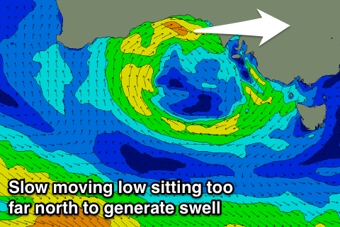
A deepening and stalling mid-latitude low off the South West of WA is expected to slowly meander east towards us through all off next week, but it will be positioned too high to generate any decent W'ly swell, with the winds being in the high Bight. This will however keep N'ly winds blowing across the South Coast all week with some fun new S/SW groundswell later Tuesday and Wednesday.
We'll discuss this in more detail Friday though.


Comments
Hello swell.
Head-high one..