Fun South Coast waves, good Mid swell again Thursday
South Australian Forecast by Craig Brokensha (issued Monday 8th May)
Best Days: South Coast Tuesday and Wednesday morning at swell magnets, both coasts Thursday and Friday morning, South Coast Saturday morning
Recap
A small clean start to the weekend down South before an onshore change moved through mid-late morning. The Mid Coast was tiny and bumpy, but into Sunday we saw our strong new W/SW groundswell filling in.
Swell magnets saw sets pulsing between 2-3ft with offshore winds and the weekend crowds were out in force. The South Coast offered solid sets and conditions improve through the morning as winds tended variable.
Today the groundswell was on the ease from 1-2ft on the Mid Coast, while the South Coast was clean and fun with sets back to 3ft off Middleton.
This week (May 9 – 12)
We've got a couple of smaller days on the cards this week ahead of a strong new W/SW groundswell Thursday.
Today's mix of W/SW and S/SW swell will drop out this afternoon, down further from a small 2ft+ off Middleton tomorrow morning and 3-4ft at Waits and Parsons with a NE-N/NE offshore. Afternoon E/SE breezes will create bumpy conditions. The Mid Coast will be clean but tiny and fading from 1ft on the sets.
Wednesday will only be worth surfing at Waits and Parsons as the swell becomes tiny at Middleton under N/NE tending N/NW winds.
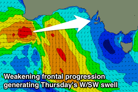
Now, moving into Thursday and our strong but distant W/SW groundswell is on track.
This groundswell was generated late last week and through the weekend with a fetch of severe-gale to storm-force W/SW winds developing west of Heard Island, projecting north-east towards WA through our western swell window.
The storm is now weakening west-southwest of WA, but we'll see a persistent fetch of strong W/SW winds aimed through our western swell window under WA, west of Bass Strait.
 We'll see the long-period fore-runners arriving Wednesday, but the bulk of the swell is due Thursday, peaking through the afternoon.
The Mid Coast should build to 2ft to occasionally 3ft with the push of the tide while Middleton won't see too much size comparably with the west in the swell, building to 3-4ft.
Winds are looking good for both coasts as a weak trough tries to clip the region, but just passes south of us. This should result in variable tending locally offshore winds, tending SE into the afternoon.
Friday should see the swell slowly easing back from 2ft on the sets across the Mid Coast and 3ft+ off Middleton with a morning E/NE-NE breeze.
This weekend onwards (May 13 onwards)
Saturday is looking really fun as a new S/SW groundswell due into Friday afternoon, slowly eases through the day under offshore winds.
This swell will be produced by a flurry of broad but not overly strong polar fronts mid-late week to our south.
We should see Middleton continuing to offer 3ft waves Saturday morning, bigger at Waits and Parsons but tiny on the Mid Coast.
This swell will ease through the day and further Sunday. A morning N/NE'ly will create great conditions Saturday, while less favourable E/NE breezes are due Sunday.
Longer term, we're likely to see an intense mid-latitude low forming off the South West of WA, generating some new W/SW swell for us mid-late next week, but more on this Wednesday.

