Great Sunday, good W/SW swell Tuesday
South Australian Forecast by Craig Brokensha (issued Friday 28th April)
Best Days: South Coast Saturday, Sunday, Monday morning, Mid Coast Tuesday and Wednesday morning
Recap
Not much to surf across the Mid Coast the last two days with tiny 1ft waves.
The South Coast remained a mess yesterday but improved a little at Middleton, while today was best with a W/NW breeze and fun 2-3ft sets off the point.
This weekend and next week (Apr 29 – May 5)
We've got a fun weekend of waves due across the South Coast.
Currently a mid-latitude front passing under us is generating a fetch of strong to gale-force W/SW winds through our south-western swell window. This should produce a building mid-period SW swell tomorrow, mixed with a stronger long-period S/SW groundswell, generated earlier this week by a vigorous low in the southern Indian Ocean.
Middleton should come in around 2ft+ tomorrow morning, kicking to 3-4ft+ through the afternoon. The Mid Coast is only due to hang around 1ft.
Sunday morning should offer similar sized waves ahead of a drop through the afternoon, smaller Monday from 2-3ft across Middleton.
Winds are looking good with an early W/NW breeze due around Victor tomorrow, tending weak SW through the afternoon. This should create decent conditions through the afternoon with the new swell.
 Sunday will be great with a light N/NW tending variable breeze as a cold front approaches from the west.
This front will near closer Monday resulting in fresher NW winds ahead of a SW change early afternoon. Therefore get in through the morning for the best waves.
Monday afternoon's change will herald a run of poor onshore winds Tuesday and Wednesday along with some mid-period S/SW swell and stronger W/SW groundswell.
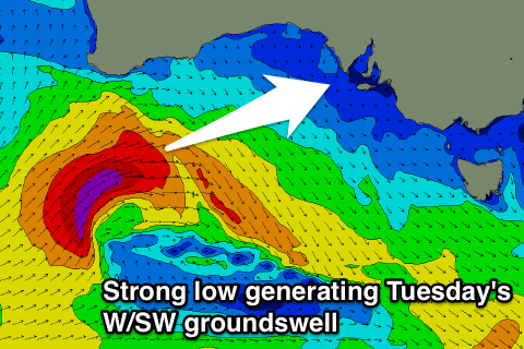
The W/SW groundswell will be generated by an initial intense low passing under WA, aiming a fetch of severe-gale W/SW winds.
A moderate to large sized W/SW groundswell should be generated, filling in Tuesday across the Mid Coast and coming in at 2ft+ with 3ft sets on the favourable parts of the tide.
The South Coast should see some decent sets developing across Middleton to 3-5ft but S/SW winds will create poor conditions. The Mid Coast is likely to see S-S/SE winds, but we'll review this Monday.
The W/SW swell will ease Wednesday with S/SE winds, while the South Coast should see the mid-period S/SW swell filling in, produced by a strong to gale-force S/SW fetch south of us early next week.
This swell is likely to peak later Wednesday/Thursday and hopefully winds will tend E/NE Thursday morning.
Longer term another moderate to large W/SW groundswell is due next weekend, produced by a very strong storm developing in the south-east Indian Ocean, but more on this Monday. Have a great weekend!


Comments
Still looking nice through the Bay early this morning.