Another large swell for South Oz
South Australian Surf Forecast by Ben Matson (issued Friday 31st March)
Best Days: Large surf at Victor this weekend, with light winds possible Sat PM and Sun AM. Small low confidence swell for the Mid Coast due to the swell direction; should be a few waves though. Not much next week with small swell and mainly light winds. New swell due next weekend.
Recap: Thursday was very large and onshore at Victor with 6-8ft sets on offer, and surf size built again throughout the Mid Coast with bumpy 2-3ft sets into the afternoon. Today we’ve seen size ease and conditions improve with light offshore winds across both coasts. Victor is still seeing 4-6ft sets and it’s around 2ft across the Mid Coast.
This weekend (Apr 1 - 2)
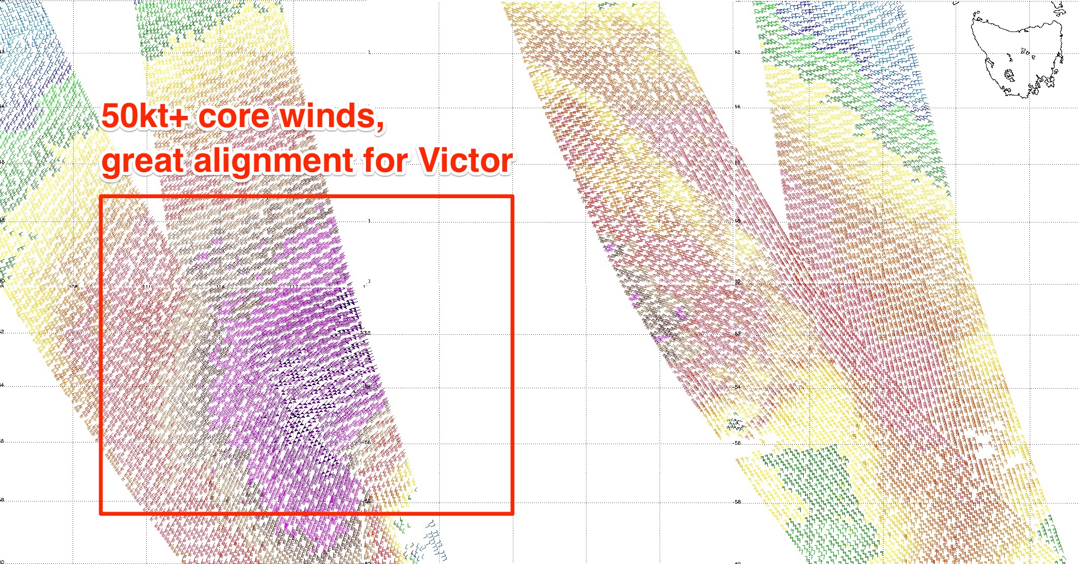
The latest satellite scatterometry have confirmed a broad fetch of 50kt+ winds associated with the Southern Ocean low that’s producing the weekend’s large swell. However several passes missed the core fetch (see below) which is expected to be closed to 60kts.

Anyway, this is a moot point - the model output has been consistent all week, the satellite data has confirmed the model guidance and so we’re looking at very large long period groundswell building across the South Coast through Saturday, peaking late afternoon and easing slowly from Sunday morning.
Unfortunately, the peak of this swell will coincide with a cold front crossing the region - attached to the same low that produced the swell (though it's now weakening). This will bring a SW change some time early on Saturday morning. Victor Harbor may see an hour or so of light W/NW winds if we're lucky but it’ll be a small window at best (if at all) and will also coincide with a period of smaller waves (3-4ft Middleton).
The afternoon should see surf size push up into the 6-8ft range at most open South Coast locations (obviously smaller across the Chiton/Dump region), and I wouldn’t be surprised it the last few hours of the day saw occasional 8-10ft wash-throughs at exposed locations. But, winds will be onshore SW by this time - probably easing from the strength immediately behind the change - so this could be workable if you don't mind a few bumps.
Along the Mid Coast we should see a small bump in size during the afternoon from an early dip (inconsistent 1-2ft at dawn). However, I’m not as confident on this swell for the Mid, because the low responsible for the swell formed to the east of its swell window, meaning Kangaroo Island will largely shadow the Mid Coast for any meaningful size.
But due to the sheer size and strength of this system, it’s possible that we’ll see an afternoon kick into the 2ft+ range. We should also see an afternoon easing in the S/SW airstream, maybe a late S/SE breeze if we are lucky. So keep an eye on the South Port cam after lunch.
Expect an easing trend from Sunday. Early morning may see some 6ft+ sets across reliable South Coast swell magnets, but in general it’ll be down to 4-6ft by late morning thru' lunchtime and then 3-5ft by the late afternoon. The models are maintaining a light to moderate SE winds on Sunday but we should see local topographical influences swinging this around to the NE at Victor Harbor early morning 9though trending onshore during the day).
Across the Mid Coast, expect very inconsistent surf in the 2ft+ range on Sunday with light offshore winds. Whilst I’m expecting a drop in size down south on Sunday, the Mid Coast’s Sunday session will have been generated by an earlier, better positioned phase of this low pressure system, further west. However it’s hardly a high confidence event and the upper end of this size range will probably only appear with the push of the tide. So keep your expectations low for weekend waves on the Mid Coast.
Next week (Apr 3 onwards)
Nothing of any major interest for next week. A moderate series of poorly aligned fronts will maintain small surf across the South Coast all week but without anything overly special.
A weak ridge of high pressure south of the state will create mainly light variable winds, from the east if anything. The Mid Coast may see very small waves at times but it won’t be worth any effort - perhaps Monday at best for some small leftovers from the weekend.
Next weekend is looking at slightly better swell pushing through as the storm track pushes a little closer to the mainland, providing a lift for both coasts though winds are tricky as they’ll be influenced by a cold front. There’s a suggestion for a large swell early in the following week but that’s a long time away, let’s take a closer look on Monday.
Have a great weekend! See you Monday.


Comments
Winds have gone S/SE across the Mid but it's still bumpy up the face. Average 2ft sets at South Port by the look. Buoy trend still on the way up though which is great.
Solid down south!
The swell is kickarse , battering the coast here .
Nice clean lines on the Mid this morning. Could be some bigger sets but this is what I saw in the space of a couple of minutes.
Wow, look at hump. Almost makes me wistful
Still some clean 1-2ft sets across the Mid Coast.