Fun Sunday, large swells for next week
South Australian Forecast by Craig Brokensha (issued Friday 24th March)
Best Days: Sunday morning South Coast, dawn Monday for keen surfers down South, Tuesday both coasts, early Wednesday Mid Coast, all day down South
Recap
Tiny waves across the Mid Coast yesterday and this morning, while the South Coast offered plenty of size but poor conditions yesterday. Much cleaner waves were seen today with good peaky 2-3ft sets off Middleton and more size out west of town.
This weekend and next week (Mar 25 – 31)
The outlook for the weekend is the same, with some small inconsistent SW groundswell pulses due across the South Coast with favourable winds.
You'll get the most bang for your buck at swell magnets with small 1-2ft waves due off Middleton tomorrow, better to 3ft on the sets at Waits and Parsons.
Sunday should be a bit better with 2ft+ waves off Middleton and 3-4ft sets at Waits and Parsons. Into the afternoon a very inconsistent long-range W/SW groundswell should show, produced in our far swell window around Heard Island.
 Middleton is likely to see better 2-3ft sets, while the Mid Coast will hopefully pulse to 1-1.5ft through the afternoon/evening. The swell should ease Monday from 2ft+ and 1ft respectively.
A light variable wind is expected early tomorrow, but we may see a shallow change by 8am. So it's probably not worth driving from Adelaide for.
Sunday will be better with a light offshore N/NE breeze before sea breezes kick in.
Into Monday there's a good chance for a NW breeze at dawn, but a gusty W/SW change will move through mid-morning, with an increase in W/SW windswell and groundswell due across the Mid Coast to 2ft+.
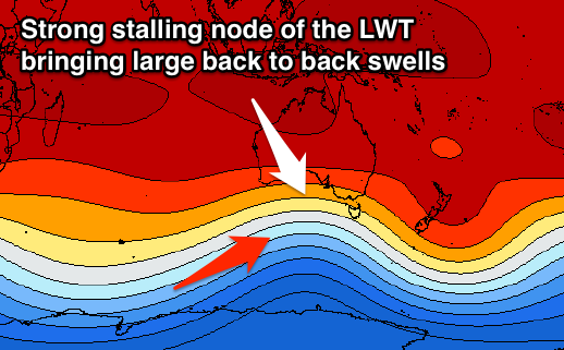
Monday's change and building swells will be associated with a vigorous cold outbreak in the Southern Ocean owing to a strong node of the Long Wave Trough moving in across the country.
The Long Wave Trough dictates the Southern Ocean storm track and its strength, and with this node moving slowly through the Bight while strengthening, we'll see a significant frontal progression extending from us to the south-west of WA.
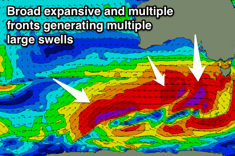
The stalling nature of the LWT will see strong embedded fronts projected through our swell window generating tricky but large pulses of swell all next week.
The first increase for later Monday and more so Tuesday will be produced by an intense mid-latitude low forming south-west of WA this evening, projecting west towards us over the weekend and Monday while generating W/SW gales.
 A moderate to large W/SW groundswell will be generated, building later Monday to 2ft+ on the Mid Coast, peaking Tuesday to 3ft on the sets.
The swell will be fairly west for the South Coast, but with the front dipping south-east Monday we'll see is exposed to a fetch of gale to severe-gale W/SW winds.
This should produce 3-4ft waves off Middleton Tuesday, larger at Waits and Parsons. Winds on Tuesday are looking variable across the Mid, creating great conditions and light from the NW down South, variable across both coasts into the afternoon.
Behind this first front an expansive fetch of severe-gale to near storm-force W/SW winds will be drawn out all the way from us to south-west of WA.
The strongest winds will be further away from us, generating a large less consistent long-period SW groundswell for Thursday, while severe-gale W/SW winds generated south of the Bight Monday afternoon will generate a moderate to large W/SW swell for later Tuesday and more so Wednesday morning.
Middleton should see 3-5ft sets Wednesday morning, with the Mid Coast dropping back to 2ft, with 3ft sets on the favourable parts of the tide. Conditions look great down South with a NW tending W/NW offshore, while the Mid Coast may see early variable winds if we're lucky.
The SW groundswell for Thursday looks to be more in the 6ft range off Middleton and 2-3ft on the Mid Coast but with poor SW winds. With the dynamic and fluid nature of this progression there's bound to be revisions, so check back here Monday for the latest on next week's outlook. Have a great weekend!

