Easing surf with improving winds down South, strong swell for Monday
South Australian Forecast by Craig Brokensha (issued Friday 17th March)
Best Days: Both Coasts Saturday morning, Sunday mid-morning-early afternoon down South, Mid Coast keen surfers Monday, Mid Coast Tuesday morning
Recap
A spike in W/SW windswell across the Mid Coast yesterday morning to a bumpy and choppy 2ft, easing a little through the day before a strong pulse of new W/SW groundswell filled in.
This swell reached an easy 3ft into the evening but conditions only started to really improve just before dark. The South Coast was small and weak in the morning, bigger later.
Today offshore winds cleaned up the W/SW groundswell with 2-3ft at Mid Coast swell magnets (footage below), while the South Coast was better but still average with a fresh E'ly wind.
This weekend and next week (Mar 18 – 24)
Later yesterday's and this morning's strong W/SW groundswell is on the ease and will continue to ease back to 1-2ft on the favourable parts of the tide across the Mid Coast tomorrow.
The South Coast will be small and easing from 2ft max at Middleton but bigger at Waits and Parsons. A light to moderate NE'ly wind should create good conditions ahead of sea breezes, while Sunday will see a straighter offshore wind but no real size in the morning.
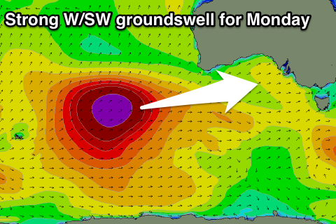
Into the afternoon a very inconsistent long-range W/SW groundswell should build (with a better pulse for Monday).
 Sunday's swell should kick strongly later in the day to 3ft at Middleton if not for the odd bigger one, but conditions will be average with sea breezes.
The Mid Coast should also increase later but only to 1-1.5ft.
The larger swell for Monday has been generated by a re-intensification of the polar low linked to Sunday's swell in the Heard Island region, projecting a fetch of severe-gale to near storm-force W/SW winds north-east towards WA (through our western swell window).
A peak is due through the morning/middle of the day Monday with strong but inconsistent 3-5ft sets off Middleton and 2ft on the Mid Coast (3ft sets on the favourable parts of the tide).
Unfortunately our poor wind outlook for Monday is holding with a deepening surface trough to our west expected to move in overnight Sunday, bringing strengthening S'ly winds Monday, persisting through until Thursday.
The wind will be better for the Mid but not great with cross-shore S-S/SE breezes.
Longer term a fun S/SW groundswell is due Thursday but this will be spoilt by SE-S/SE winds, cleaner into Friday as it eases. We'll review this Monday. Have a great weekend!


Comments
Nice lines on the Mid Coast this morning.
South Port's starting to push into the 2-3ft range now.