Very average outlook, better from Wednesday next week
South Australian Forecast by Craig Brokensha (issued Wednesday 8th February)
Best Days: No good days until next Wednesday
Recap
Tiny to flat waves on the Mid Coast yesterday and today, while the South Coast was a mess with a junky south-east windswell.
Today cleaner conditions were seen down South with fading 1-2ft waves off Middleton and a bit more power at Waits and Parsons.
This week and weekend (Feb 9 – 12)
Make the most of this morning's waves, as the outlook for the coming period isn't good at all.
We're looking at light variable winds and clean conditions again tomorrow morning, but the surf will be tiny to flat across both coasts. A gusty S'ly change is due through the day kicking up a late increase in weak windswell.
Friday will won't be any better with moderate to fresh S/SE winds along with a small weak S/SE windswell.
The Mid Coast should see tiny 1ft sets, from the early stages of the trough off WA today, aiming a less than favourable SW fetch briefly in our swell window.
 Into the weekend the poor conditions will continue with moderate S/SE breezes Saturday and a poor mix of small background SW swell and S/SE windswell.
Some better SW swell is expected to build through Sunday followed by S/SW swell Monday and Tuesday.
Sunday's swell will be generated by a relatively weak but persistent polar front projecting a fetch of strong to near gale-force W/SW winds from south-west of WA, through our south-west swell window later this week.
The Mid Coast should see a little 1ft wave off this fetch, with the South Coast building to 3ft across Middleton through the morning. Unfortunately winds will be onshore from the S/SW on Sunday, associated with the frontal progression, kicking up a poor quality S/SW windswell into the afternoon as well.
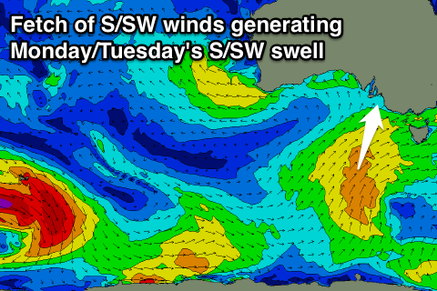
Some bigger S/SW swell energy is due to fill in Monday afternoon and Tuesday, produced by a secondary better aligned polar front projecting a similar strength fetch of S/SW winds up through our southern swell window Saturday and Sunday.
We'll see Middleton reaching 3-5ft through the afternoon with 4-6ft sets at Waits and Parsons but with persistent and fresh S/SW winds. The Mid is expected to remain tiny and bumpy.
A drop in swell is expected Tuesday but with E/SE-SE winds, while Wednesday is the pick as winds finally swing offshore from the NE.
Longer term some good new swell energy is due late week, but we'll look at this in more detail Friday.

