Great weekend, very average next week
South Australian Forecast by Craig Brokensha (issued Friday 3rd February)
Best Days: South Coast Saturday, Sunday morning
Recap
Tiny leftovers across the Mid Coast yesterday to 1ft with early light winds ahead of an onshore change.
The South Coast was also expectantly clean early with smaller surf, best at Middleton before the onshore change moved in.
Today a new pulse of SW swell has filled along down South to 3ft off Middleton with light offshore breezes, while the Mid was continuing at 0.5-1ft.
This weekend (Feb 4 – 5)
The weekend is looking great down South with another pulse of SW swell for tomorrow, easing Sunday under favourable winds.
This morning's first pulse of SW swell should ease later today, with another similar sized pulse due to fill in tomorrow. These swells have been generated by back to back mid-latitude frontal systems under the Bight, pushing towards Victoria.
We should see Middleton build back to the 3ft range through the day (a touch smaller early), with 1ft sets on the Mid.
Easing surf from 2-3ft is then expected on Sunday down South (bigger at Waits and Parsons) with tiny fading waves on the Mid.
A light morning offshore is due tomorrow, with weak sea breezes kicking in mid-afternoon.
Sunday will be similar, but a NW'ly will develop late morning ahead of a gusty S'ly change through the afternoon.
Next week onwards (Feb 6 onwards)
Sunday's change will be linked to a strong high pressure ridge moving in from the west and we'll see poor and strong S/SE winds across the South Coast Monday, kicking up a poor windswell.
Winds are due to swing more E'ly on Tuesday as the E/SE windswell eases, mixed in with a small weak SW swell. Another lay day.
 The Mid Coast isn't due to provide any size at all.
Wednesday will become cleaner with a NE-N/NE offshore but there'll be no decent swell left at all, with tiny waves off Middleton (2ft max Waits and Parsons).
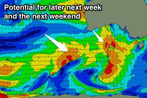
A trough moving through Thursday will bring another episode of strong S/SE winds and windswell, but some new W/SW and SW groundswell is due into Friday and the weekend from a strong and deepening low forming under WA, dipping south-east through our swell window.
We'll have another look at this Monday though, in the meantime enjoy the weekend.

