Fun swells continue, smaller from early next week
South Australian Forecast by Craig Brokensha (issued Monday 30th January)
There's only TWO DAYS left to sign up for the P-Pass competition! Sign up to Swellnet’s newsletter and receive the South Australian Forecaster Notes and latest news sent directly to your inbox. Upon signup you'll also enter the draw to win a surf trip to P-Pass for you and a mate. It doesn’t get much easier so click HERE to sign up now.
Best Days: Mid Coast tomorrow and Wednesday, South Coast Wednesday morning, Friday morning and the weekend each morning
Recap
Fun levels of W/SW swell all weekend, around 1-1.5ft on the Mid Coast (pulsing to 2ft with the tide Saturday afternoon but less so Sunday), while Middleton hovered between 2-3ft with clean conditions Saturday morning, a little more peaky and wobbly Sunday.
Today the surf was was a little smaller with sets back to 2ft off Middleton, while the Mid Coast is around 1ft with the odd bigger one at magnets but with an onshore wind.
This week and weekend (Jan 31 – Feb 5)
Through this week and weekend we'll continue to see small to moderate pulses of W/SW-SW swell across the state, generated by persistent weak mid-latitude frontal activity south-west of and under the country.
The size will ebb and pulse day to day with tomorrow's and Wednesday's swell being more W/SW in nature, before the swell comes more from the SW Friday and Saturday.
 Over the weekend an intense mid-latitude low generated a good swell which impacted Margaret River this morning and will fill in tomorrow across our state.
We should see the swell peaking through the middle of the day with 1-2ft sets on the favourable part of the tide across the Mid Coast and 3ft waves off Middleton.
This swell will ease into Wednesday, but a reinforcing W/SW swell is due, produced by a broad fetch of strong W/SW winds currently passing just south of the Bight.
This should keep 1-1.5ft+ waves impacting the Mid Coast (2ft on the sets on the favourable part of the tide), while the South Coast should continue around 3ft off Middleton.
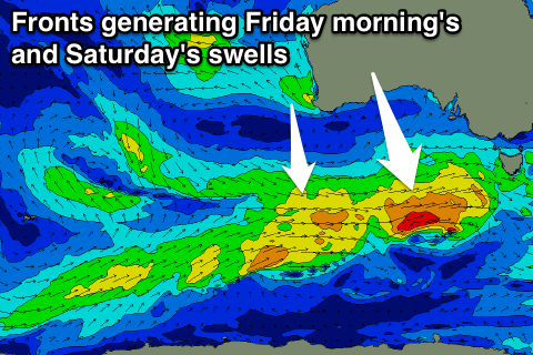
A low point in swell is due Thursday as we fall in between fronts and swell, but come Friday a new SW groundswell is due from a strengthening mid-latitude front south-west of us on Wednesday.
This swell should see 2-3ft sets across Middleton, while the Mid Coast is only due to be around 1ft.
A secondary less favourably aligned front will generate a slightly smaller swell for Saturday morning, to 2ft to nearly 3ft across Middleton.
One final pulse of reinforcing SW swell is expected on Sunday and after this the mid-latitude storm track will settle down resulting in a drop in energy into early next week.
Coming back to the winds, and in the wake of today's change, S/SE winds should be seen on the Mid through the morning, S/SW on the South Coast, with variable winds Wednesday morning.
A weak change on Thursday will leave onshores across the South Coast again, likely tending S/SE on the Mid and then Friday will see variable breezes again.
Saturday morning is looking at local offshore winds and then Sunday similar ahead of a change. We'll confirm this Wednesday but.


Comments
You're starting to write like an east-coaster speaks Craig. "We'll confirm this Wednesday but."
Haha, noted, maybe a little too relaxed.
Couple of peaks showing at The Hump now.