More W/SW swell to come
South Australian Forecast by Craig Brokensha (issued Friday 27th January)
Sign up to Swellnet’s newsletter and receive the South Australian Forecaster Notes and latest news sent directly to your inbox. Upon signup you'll also enter the draw to win a surf trip to P-Pass for you and a mate (this is the final week). It doesn’t get much easier so click HERE to sign up now.
Best Days: Mid Coast the whole period, South Coast Saturday morning, Sunday morning, Monday morning
Recap
Good waves on the Mid Coast yesterday afternoon when the tide filled in, pulsing to 1-2ft with favourable winds. The South Coast was average and bumpy.
This morning the swell was hanging around 1-1.5ft again on the Mid, and we should see some better sets with the tide again this afternoon. The South Coast was cleaner with small 2ft waves off Middleton.
This weekend and week (Jan 27 – Feb 3)
The weekend's better pulses of W/SW groundswell are still on track, with the most size due on Sunday across both coasts.
An initial inconsistent W/SW groundswell pulse is due tomorrow, similar in size to today with 1-1.5ft sets on the Mid (pulsing to 2ft on the sets with the tide), while the South Coast should see 2ft to occasionally 3ft waves off Middleton.
A variable breeze should create clean conditions across both coasts tomorrow morning, bumpy into the afternoon with sea breezes.
 Sunday morning is looking clean as well with an E/NE offshore down South, E/SE on the Mid and a good building W/SW swell.
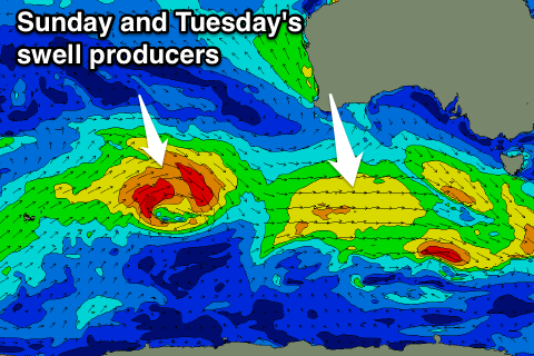
This swell has and is still being generated by a persistent mid-latitude low coming in from the west.
Fun 2ft waves are due on the Mid Coast into the afternoon while Middleton should build to 3ft+. Afternoon sea breezes will create bumpy conditions down South, while the Mid should remain clean.
A drop in swell is expected through Monday from 1-2ft on the Mid and 3ft at Middleton but conditions will be great with offshore N/NE winds, tending NW late morning ahead of a change early afternoon.
More W/SW swell is due through next week, the first Tuesday followed by some secondary energy Wednesday.
Tuesday's swell will be produced by a mid-latitude low in the south-east Indian Ocean, generating a fetch of pre and post-frontal gales before weakening while passing under the Bight.
A secondary weaker but broader system will then move in on the tail of the initial system.
We should see persistent amounts of W/SW swell from Tuesday through Thursday morning to 1-2ft on the Mid Coast (most consistent and biggest likely Wednesday afternoon) and 3ft on the South Coast.
Winds on Tuesday will be from the S'th, tending S/SE on the Mid with better SE winds Wednesday for the Mid, persisting Thursday. More on this Monday though, have a great weekend!

