Small fun W/SW swells all week
South Australian Forecast by Craig Brokensha (issued Monday 23rd January)
Sign up to Swellnet’s newsletter and receive the South Australian Forecaster Notes and latest news sent directly to your inbox. Upon signup you'll also enter the draw to win a surf trip to P-Pass for you and a mate (this is the final week). It doesn’t get much easier so click HERE to sign up now.
Best Days: Mid Coast later tomorrow then the whole period working the tide, South Coast Wednesday and Friday mornings, Saturday morning, Monday morning
Recap
Average onshore waves Saturday morning across the South Coast, a little better but still small Sunday with a more favourable morning offshore.
The Mid Coast started slow Saturday but a new W/SW groundswell pulsed into the afternoon, cleaning up late while Sunday saw 1-1.5ft waves, just a slight tease all day.
This morning was back to 1ft and clean again, while the South Coast was better at magnets with the light offshore wind and small swell.
This week (Jan 24 - 27)
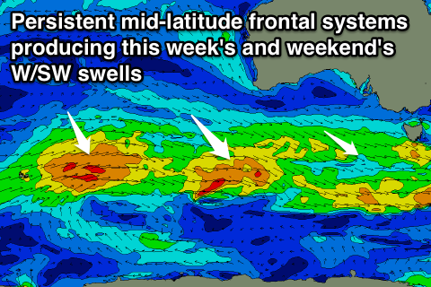
From tomorrow, small pulses of W/SW swell are due across the state, generated by relatively weak but persistent mid-latitude fronts moving in from the south-east Indian Ocean, under the country.
The first swell tomorrow afternoon and early Wednesday will have the most west in it, generated by a weak front currently approaching through the Bight.
 While only weak, the front is ideal for the Mid, offering consistent 1-2ft waves all day. The South Coast is only due to be small and around 1-2ft as well, building a little more into the afternoon before peaking Wednesday morning around 2ft+.
Secondary systems positioned a little further south should keep small inconsistent 2ft waves hitting Middleton through Thursday and Friday while the Mid Coast is due to be around 1-1.5ft for the most part.
Coming back to the winds and onshore S/SW breezes are due across both coasts all day tomorrow, tending back to the S/SE late on the Mid creating cleaner conditions.
An offshore E/SE breeze is due Wednesday (likely tending E/NE down South), while winds will revert back to the SE on Thursday. Friday looks cleanest down South with an offshore NE breeze.
This weekend onwards (Jan 28 onwards)
Into Saturday the swell should continue around the same size, if not a little stronger with a slight uptick in swell period due to winds in the westerly storm belt strengthening a little.
Into Sunday however a slightly better pulse is due, produce by a slow moving fetch of strong to near gale-force W/SW winds moving through our far western swell window before continuing towards Tasmania through our south-western swell window.
This swell should build through the afternoon and reach a good 2ft on the Mid Coast, while the South Coast should see sets reaching 3ft off Middleton.
Winds on Saturday look good early and variable ahead of a shallow SW change. A swing back to E/SE breezes is expected on Sunday with possibly some OK waves down South.
Monday looks cleanest down South with a morning offshore. More on this Wednesday.

