W/SW swells keep on keeping on
South Australian Forecast by Craig Brokensha (issued Friday 20th January)
Sign up to Swellnet’s newsletter and receive the South Australian Forecaster Notes and latest news sent directly to your inbox. Upon signup you'll also enter the draw to win a surf trip to P-Pass for you and a mate (there's only 1 week left to go). It doesn’t get much easier so click HERE to sign up now.
Best Days: Mid Coast tomorrow afternoon, both coasts Sunday, South Coast magnets Monday morning, Mid Coast keen surfers late Tuesday, Mid Coast Wednesday
Recap
Improving waves across the South Coast at spots that handle NE winds yesterday with a fun peaky swell and warm offshores. The Mid Coast hovered around 1-1.5ft, pulsing a little with the afternoon incoming tide under glassy conditions and incoming storms.
Today both coasts were poor with a cool onshore change and tiny 1ft of swell on the Mid Coast, 2-3ft down South.
This weekend (Jan 19 - 22)
The W/SW groundswell event due across the Mid Coast this weekend is looking on track. The swell came in a touch above expectations in Margaret River, but was ideally aimed for that region and there's no need to change the size expected across our state.
The swell is due to build strongly tomorrow, reaching 2ft on the sets across the Mid Coast with the incoming tide, easing off from 1-1.5ft Sunday (maybe 2ft if we're lucky).
Winds will be good most of tomorrow with an E/SE offshore, giving into S/SW sea breezes and then back to the S/SE again late.
The South Coast will be small with a junky windswell but winds are likely to tend E/NE for desperate surfers tomorrow morning.
Sunday will be the better day down South with a bit more power but only to 1-2ft at Middleton with NE tending N/NE offshores ahead of late sea breezes.
Next week onwards (Jan 23 onwards)
 Monday is expected to remain small on the South Coast and tiny on the Mid around 1ft (1-1.5ft+ late with a new swell) but into Tuesday the new W/SW groundswell is due to peak. Winds will be good again with morning N'ly offshore ahead of an afternoon onshore change Monday.
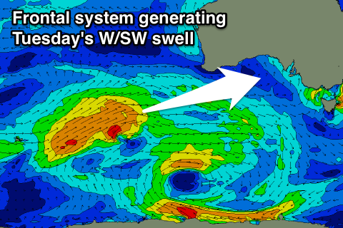
Tuesday's swell is being generated by a relatively weak but favourably tracking polar low that's currently south-west of WA and will project towards the Bight through our western swell window.
The swell should be seen later Monday but is expected to peak Tuesday to 1-2ft on the favourable parts of the tide on the Mid Coast. The South Coast is only due to see small 2ft waves off Middleton, bigger at Waits and Parsons.
A secondary front on the tail of the main system is due to move through the Bight Sunday and Monday, bringing the onshore change and this will help keep 1-2ft waves hitting the Mid into Wednesday, with a third slightly stronger but more southward tracking front producing a small SW swell for Thursday down South.
Looking at the winds though, and onshore S/SW breezes are due to persist in the wake of the low (S/SE late on the Mid), with SE winds on Wednesday and Thursday. More on this Monday though, have a great weekend!


Comments
The leading edge of the new swell hit the buoy overnight, and although only small in size, there are distinct lines at South Port. So very promising for a building trend during the day.
Buoy data can be a little deceptive - wouldn't have imagined these kinds of sets were pouring through given what's showing at CdC.