Fun South Coast waves, large W/SW swell for the weekend
South Australian Forecast by Craig Brokensha (issued Wednesday 11th January)
Sign up to Swellnet’s newsletter and receive the South Australian Forecaster Notes and latest news sent directly to your inbox. Upon signup you'll also enter the draw to win a surf trip to P-Pass for you and a mate. It doesn’t get much easier so click HERE to sign up now.
Best Days: South Coast Thursday morning and early Friday, Mid Coast Saturday afternoon and Sunday, South Coast Sunday morning and Monday morning
Recap
A tiny start to yesterday across the Mid Coast, but a new swell showed into the afternoon although with onshore winds. The South Coast saw a touch more size and variable winds created OK conditions for a surf.
Today the W/SW swell has peaked with 1-1.5ft sets on the Mid Coast and 2-3ft sets off Middleton, although winds were best for the Mid Coast.
This week and weekend (Jan 12 - 15)
Some fun sized SW swell is due tomorrow, followed by a S/SW pulse Friday morning, generated by a fetch of strong W/SW winds projecting towards Tasmania today, through our southern swell window.
Size wise, we're expecting a touch less across the South Coast with Middleton due to hang around 3ft tomorrow, and early Friday morning before easing into the afternoon.
The Mid Coast is only due to be around 1ft tomorrow, while Friday an afternoon increase in W/SW windswell to 2ft or so is due.
Conditions will be clean tomorrow morning down South with a NE offshore likely tending N'ly around midday before mid-afternoon sea breezes. Friday morning will be clean again with an early N/NW offshore but a W/SW change is due late morning/midday, kicking up that windswell across the Mid Coast.
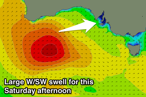
Now, into the weekend we've got a large W/SW tending SW groundswell event on the cards for the state.
 Currently an intense mid-latitude low is sitting west-southwest of WA is generating a fetch of gale to severe-gale W/SW winds through our far western swell window.
This low will move slowly east through the Mid Coast's swell window today and tomorrow while continuing to generate W/SW gales, broadening in scope and entering the South Coast's swell window on Friday while drifting a touch more south towards Victoria Friday evening and Saturday.
What we'll see is a large acute W'ly swell for Saturday, building rapidly through the morning from 2ft, to a solid 3-4ft into the afternoon. A peak is due into the evening, with easing surf from 2-3ft Sunday morning.
The South Coast is only due to be small early with mid-period W/SW swell to 2-3ft at Middleton, but the groundswell should build through the day and reach 5-6ft by dark.
Sunday is then expected to see some reinforcing S/SW swell from the backside of the low, keeping waves up around 4-5ft off Middleton all day.
Winds will be onshore Saturday from the SW, but the Mid Coast may see a late S/SE'ly on dark.
Sunday looks excellent with offshore E/SE winds before afternoon sea breezes kick in. An E/NE wind is due down South so conditions will be cleaner but still lumpy and all over the place.
Next week onwards (Jan 16 onwards)
The swell will continue to ease into Monday with easing 1-2ft sets on the Mid, while the South Coast should still be offering some fun size under an offshore N/NE breeze.
The new swell looks to arrive out of the W/SW again mid-week and this one will favour the Mid Coast with SE winds. More on this Friday though, as we've got a lot to deal with this weekend.

