Fun easing waves to end the week, good swell Monday
South Australian Forecast by Craig Brokensha (issued Wednesday 21st December)
Sign up to Swellnet’s newsletter and receive the South Australian Forecaster Notes and latest news sent directly to your inbox. Upon signup you'll also enter the draw to win a surf trip to P-Pass for you and a mate. It doesn’t get much easier so click HERE to sign up now.
Best Days: Both coasts tomorrow morning, South Coast Friday morning, South Coast Sunday morning for keen surfers, Mid Coast Monday
Recap
Poor average waves across both coasts yesterday with a small weak windswell on the South Coast and bumpy 1ft or so of swell on the Mid. A late increase in new swell was seen while today good 2ft sets were pushing into the gulf.
Conditions were OK but not great with a mix of the morning high tide and variable offshore wind. The South Coast was also better with some stronger groundswell but average winds.
The observations off Cape du Couedic are strong and with this we should see sets near 3ft showing on the Mid on the favourable parts of the tide, but with sea breezes, cleaning up late.
This week and weekend (Dec 22 – 25)
Today's strong pulse of W/SW groundswell should ease off through tomorrow after a peak today. The direction will also improve a little for the South Coast, coming more from the SW as the front passed under us yesterday.
The Mid Coast should ease from 1-2ft on the sets, although the morning high tide may create issues again, while the South Coast should ease back from the 3ft range off Middleton.
Conditions will be great on the Mid with a straight offshore wind ahead of afternoon sea breezes, while the South Coast will see improving waves as an E/NE-NE breeze develops mid-late morning.
Friday will be even cleaner down South with a N/NE offshore, tending variable from the NW ahead of sea breezes from mid-afternoon.
The swell will be small and easing from 2ft at Middleton and 3ft+ at Waits and Parsons. The Mid Coast is likely to only be around 1ft.
The weekend is still looking slow and small.
Background W/SW groundswell energy from the southern Indian Ocean should keep tiny 1ft waves hitting the Mid Coast both days, while the South Coast only looks to see 1-2ft sets at Middleton and 2ft to occasionally 3ft sets at Waits and Parsons.
A lingering S'ly wind may be seen on the South Coast Saturday morning, while Sunday looks cleanest with a light variable wind from the north-east and mid-late afternoon sea breezes.
 Next week onwards (Dec 26 onwards)
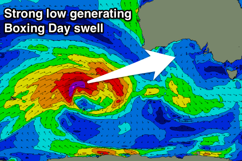
Into Boxing day a new long-range but strong long-period W/SW groundswell is due to fill in.
This is being generated by a very strong low firing up in the southern Indian Ocean this afternoon, producing a fetch of severe-gale to storm-force W/SW winds through our western swell window.
The low will slowly weaken and stall south-west of WA later this week, with the groundswell due to arrive through Monday, peaking through the middle of the day to 2ft on the Mid Coast and 3ft+ at Middleton.
There will be a wait for the sets though and S/SE winds will favour the Mid over the South Coast. We'll review this on Friday though.


Comments
The swell really kicked with the incoming tide yesterday with easy 3ft sets and a coupla bigger ones.
Good to be back home!