Best Monday morning, good W/SW swell mid-week
South Australian Forecast by Craig Brokensha (issued Friday 16th December)
Sign up to Swellnet’s newsletter and receive the South Australian Forecaster Notes and latest news sent directly to your inbox. Upon signup you'll also enter the draw to win a surf trip to P-Pass for you and a mate. It doesn’t get much easier so click HERE to sign up now.
Best Days: Sunday morning South Coast, Monday South Coast, later Wednesday Mid Coast, Thursday Mid Coast
Recap
Some tiny clean waves to 1-1.5ft on the favourable parts of the tide across the Mid Coast while the South Coast had plenty of size but with a fresh SE winds.
Today was cleaner but tiny on the Mid with full 0.5-1ft sets, while the South Coast was much better with a light E'ly wind and lumpy but improving 3-4ft off Middleton.
This weekend (Dec 17 – 18)
Tomorrow is a lay day with a fresh and gusty S/SW change due to push in around 7am creating poor conditions across both coasts as today's swell becomes small.
If you're in the region and up at dawn Middleton might have a wave before the change.
This change is now due to be a bit stronger, producing an afternoon increase in SW windswell which will peak Sunday morning, with a new inconsistent SW groundswell.
Middleton is still expected to come in around 3ft with 4-5ft sets at Waits and Parsons, while the Mid will likely pick up 0.5-1ft sets.
Conditions will be much cleaner with an E/NE-NE breeze due to develop down South, creating peaky waves, best suited to Goolwa and Parsons.
Next week onwards (Dec 19 onwards)
 Monday is still looking the best day to surf down South with a fresh and hot offshore N/NE tending N/NW breeze and late W'ly change.
Middleton should be easing from 2ft+ with 3ft+ sets at Waits and Parsons, small into the afternoon.
Small surf is then expected on South Coast Tuesday but the change due later Monday should produce some W/SW windswell on the Mid, ahead of a stronger increase in groundswell later in the day, peaking Wednesday.
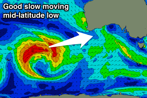
Currently an intense and slow moving mid-latitude low in the southern Indian Ocean is producing a fetch of W/SW gales through our western swell window.
The low is expected to move slowly east over the weekend while weakening slightly, producing a fetch of strong W/SW winds through the Bight Sunday and Monday before re-strengthening under us Tuesday.
What will result is a moderate to large W/SW groundswell event, building through Tuesday and peaking Wednesday.
The Mid should be around 1-1.5ft Tuesday morning, building to 2ft into the afternoon, with larger 2ft to occasionally 3ft sets on the favourable parts of the tide Wednesday.
The South Coast will see plenty of size building from the W/SW and then tending SW as the low drifts under us.
Besides a possible dawn W'ly down South a SW tending S'ly breeze will create average conditions across all locations. The Mid should see winds tend S/SE on dark.
Thursday looks cleanest but mainly for the Mid as the swell eases from 2ft on the sets. More on this Monday. Have a great weekend!


Comments
Couple of fun small peaks at The Hump.