Average for most of the week, improving from Friday evening
South Australian Forecast by Craig Brokensha (issued Monday 5th December)
Best Days: Wednesday swell magnets down South, later Friday on the Mid, both coasts Saturday morning
Recap
A good weekend of waves with clean 1-2ft surf on the Mid Coast Saturday (a touch under the expected 2ft+) and clean 3-4ft waves off Middleton with an E/NE breeze.
Sunday was a similar size down South and conditions improved through the day before winds got a little too strong mid-late morning, easing off into the afternoon again as the swell eased steadily. The Mid was clean but back to 1-1.5ft, deteriorating into the afternoon.
This morning there wasn't any size left across either coast with onshore 1-2ft waves down South and tiny bumpy waves on the Mid. A new W/SW swell was expected to fill in today in the wake of the change and this is now coming in at 1-1.5ft with lighter winds. We may see the odd bigger set, but 1-1.5ft is likely the most size we'll see today.
This week and weekend (Dec 6 - 11)
The front behind this morning's onshore change has aimed a fetch of W/SW gales on the edge of our southern swell window this morning and this should produce a small spike in SW swell for the South Coast tomorrow morning.
Middleton should offer a 2ft wave, dropping through the day while the Mid Coast is expected to ease from 1ft on the sets.
Conditions should be OK across both coasts but not perfect with a light S/SE breeze on the Mid, and similar light S/SE tending variable breeze down South before sea breezes kick in.
Wednesday morning will be super clean down South with a N/NE offshore but there isn't due to be any size left with fading 1-1.5ft sets along Middleton and 2ft+ waves at Waits and Parsons.
A low point in swell is expected early Thursday morning, but this will be temporary, with a building SW windswell due from mid-morning as a cold front pushes across us.
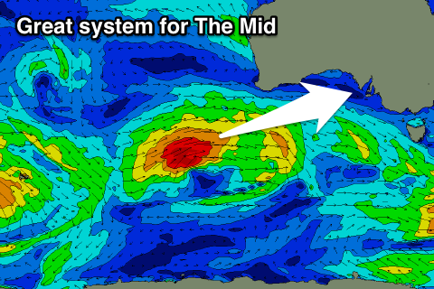
This change will actually shed off and race ahead of a swell produced by a stronger polar low that's currently south-west of WA.
 A fetch of gale to severe-gale W/SW winds are being generated in our far western swell window, before tracking east-northeast towards the Bight and ideally through the Mid Coast's swell window tomorrow and then weaker Wednesday.
The front itself will aim a fetch of strong SW tending S/SW winds through our swell window, with a building mid-period SW swell Thursday afternoon to a stormy 3-4ft at Middleton and 2ft+ on the Mid Coast by mid-morning.
This swell is expected to ease out of the S/SW Friday morning down South, but the W/SW groundswell from the low proper should fill in, offering stronger 3ft sets on the Mid Coast through the afternoon.
The South Coast won't see too much size with the westerly direction, likely holding around 3ft+ Friday afternoon at Middleton and then easing from 3ft Saturday morning.
Poor S/SW winds are expected on Friday, but a late swing to the S/SE is due on the Mid again, creating fun waves for the late session.
Saturday will be clean with an E/SE offshore on the Mid, with a light morning E/NE down South.
Sunday looks average with fresh E/SE offshores and small easing surf.

