Not the most exciting outlook
South Australian Forecast by Craig Brokensha (issued Friday 25th November)
Sign up to Swellnet’s newsletter and receive updates on when the South Australian Forecaster Notes are looking better as well as the latest news sent directly to your inbox. Upon signup you'll also enter the draw to win a surf trip to P-Pass for you and a mate. It doesn’t get much easier so click HERE to sign up now.
Best Days: Sunday morning South Coast, Monday morning South Coast, Tuesday morning swell magnets South Coast
Recap
The Mid Coast continued to offer some fun sets yesterday morning to 1-1.5ft before onshore winds kicked in and created poor conditions. The South Coast was also fun with lumpy and peaky small waves best suited to Parsons.
This morning was poor across all locations with a tiny onshore swell down south and tiny waves on the Mid.
This weekend and next week (Nov 26 – Dec 2)
The weekend's swell has been downgraded a touch further, with the back to back frontal progression pushing towards Victoria being a little weaker and positioned a touch further south.
With this we'll see mid-period S/SW energy filling in through tomorrow, coming in around 2-3ft at Middleton during the morning, larger to 3ft+ through the afternoon.
Easing surf from 3ft+ is then due Sunday, smaller from 2ft+ Monday morning.
The swell will be too south for the Mid with tiny to flat conditions expected.
Winds at dawn tomorrow will likely be onshore from the S/SE, easing and tending more variable through the morning before increasing again into the afternoon.
This isn't ideal and Sunday is the better bet with more swell and a morning offshore NE wind.
Into Monday as the swell continues to ease a light morning E/NE breeze will produce OK conditions, best at Goolwa and Parsons
 Through the rest of next week there's nothing significant on the cards at all, with a small pulse of weak SW swell for Tuesday from a small short-lived mid-latitude low.
Winds will be similar to Monday with a light E/NE'ly likely down South while onshore winds are expected to kick back in from Wednesday.
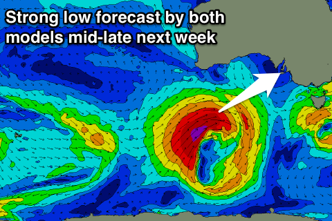
Longer term a good new W/SW groundswell is on the cards for next weekend produced by a strong low forming in our swell window, but more on this Monday. Have a great weekend!

