Great waves tomorrow and Friday morning with onshore large waves Saturday
South Australian Forecast by Craig Brokensha (issued Wednesday 2nd November)
Best Days: South Coast tomorrow and Friday morning, protected spots South Coast early Sunday, Monday South Coast
Recap
Average onshore waves around 1-1.5ft yesterday morning on the Mid, pulsing a little to 2ft on the sets into the afternoon as winds eased a touch. The South Coast was great with good winds for semi-protected spots and 3-4ft of swell off Middleton.
Today the Mid was smaller again to a bumpy 1ft, while the South Coast saw similar sized waves but conditions were a little mixed with a variable wind from the west.
This week and weekend (Nov 3 - 6)
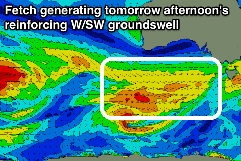
 From today we'll see the surf slowly easing across the South Coast, but this will be slowed tomorrow by a reinforcing W/SW swell tomorrow, generated by a broad fetch of W/NW gales currently passing under the Bight.
Middleton should continue to offer 3-4ft sets all of tomorrow, easing more noticeably from 3ft Friday morning.
The Mid should see 1-1.5ft sets tomorrow, tiny from Friday.
Conditions will be great across both coasts tomorrow with a light E/NE offshore on the Mid, variable into the afternoon and N/NE tending N/NW down South ahead of sea breezes.
Friday will be best in the morning with a fresh N/NW breeze ahead of a W/SW change early afternoon.
This change will be linked to a vigorous cold front pushing south of us. The structure of this system isn't great, but a fetch of gale to severe-gale W/SW winds will be generated through our south-western swell window from tomorrow afternoon through early Saturday, generating a moderate to large SW groundswell for Saturday.
A peak is expected through the middle of the day/early afternoon down South to a strong 4-6ft along the Middleton stretch, larger at Waits and Parsons, with 1-2ft waves on the favourable parts of the tide across the Mid, more so the afternoon.
A secondary tight system racing in behind the initial front will generate an additional fetch of W/SW gales through our swell window Saturday and early Sunday, generating a reinforcing SW groundswell for later Sunday afternoon and Monday morning.
Sunday is expected to ease slightly from 3-4ft+ at Middleton, with the new swell keeping 3-4ft sets into Monday morning before fading into the afternoon.
The Mid Coast is only expected to be around 1ft or so.
Conditions on Saturday with the building swell will be average with a fresh to strong SW breeze, easing through the day, with W/SW winds Sunday (likely W/NW around Victor for a period). Monday morning looks the best with a fresh N/NW'ly ahead of a late change.
Longer term moderate amounts of SW swell are due to persist on the coast most of next week, more on this Friday.

