Great waves down South tomorrow, workable Friday onwards
South Australian Forecast by Craig Brokensha (issued Wednesday 5th October)
Best Days: South Coast tomorrow, Mid Coast early, Friday morning protected spots South Coast, Saturday morning peaky waves in protected spots, swell magnets Sunday morning
Recap
Stormy 4ft waves across the Mid Coast again yesterday, finally settling back down into today more to 2ft with a weaker NW breeze. The wind should tend more variable into the mid-late afternoon, creating even better conditions.
The South Coast was bumpy and choppy yesterday with strong to gale-force W'ly winds, much better today with a good 3-4ft of swell off Middleton and good winds.
This week and weekend (Oct 6 - 9)
Our reinforcing pulse of SW groundswell for tomorrow is still on track, with a vigorous front moving under us today, generating a fetch of gale to severe-gale W/NW winds through our swell window.
Some good SW swell should spread out radially up towards us, coming in at 3-4ft along the Middleton stretch, while the Mid Coast is expected to see 1-2ft waves, easing through the day.
Friday will then be tiny on the Mid, with the South Coast hanging around 2-3ft at Middleton.
Winds tomorrow will be great for the South Coast with a freshening N/NE tending N/NW breeze, workable on the Mid early. Friday then should see an early W/NW'ly down South ahead of a shallow SW change into the afternoon.
One final pulse of SW groundswell is due Saturday morning from a mid-latitude frontal system dipping south-east from WA and then moving towards Tassie Thursday and Friday.
A post-frontal fetch of W/SW winds should produce a mid-period SW swell for Saturday morning, easing into the afternoon and further Sunday.
 Unfortunately conditions Saturday won't be perfect with an E/NE breeze creating peaky conditions ahead of afternoon sea breezes, while Sunday should then see better N/NE winds ahead of a late W'ly change.
3ft sets are due across Middleton Saturday morning, smaller into the afternoon and fading from 2ft Sunday. The Mid is expected to be tiny.
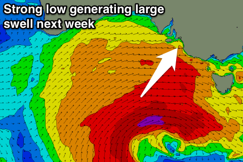
Now, as discussed Monday, a vigorous and deepening low pressure system is forecast to develop south-west of us later in the weekend.
This should produce a large SW groundswell for early next week but with generally onshore SW winds. We'll have a closer look at this

