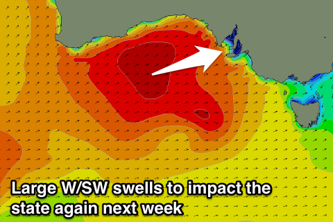
Great Saturday down South, return to winter next week
South Australian Forecast by Craig Brokensha (issued Friday 30th September)
Best Days: South Coast Saturday, South Coast Monday onwards, Mid Coast Wednesday afternoon and Thursday morning
Recap
Developing stormy waves on the Mid Coast yesterday with 3-4ft of NW and W/SW swell with easing onshore winds. The afternoon was best for a wave as winds became more manageable.
The South Coast was clean and small during the morning before a change hit around midday.
Today the Mid Coast was back to a smaller and sloppy 2ft or so with weaker onshore winds, while the South Coast saw the most size with lumpy 4-6ft sets and cross-onshore winds.
This weekend (Oct 1- 2)
Tomorrow is the pick of the weekend!
The severe low responsible for the last few days of weather and waves is weakening while pushing east. In saying this, a fetch of strong to gale-force S/SW winds are still being aimed up into us this morning, weakening significantly into this afternoon and evening.
Easing levels of S/SW swell are due from 3-4ft+ across most locations early (bigger bombs at Waits), with Sunday not expected to offer much size at all with fading 2ft+ sets across swell magnets.
The Mid Coast should ease from 1ft+.
Conditions will be excellent all day down South with a NW tending N'ly breeze. Sunday will also be clean during the morning with a fresh N/NW wind ahead of a W'ly change, but remember the swell will be weak small and fading. The Mid Coast should see building levels of W/NW windswell into the afternoon.
Next week onwards (Oct 3 onwards)
We'll see another wintery blast next week as a series of vigorous mid-latitude fronts fire up towards WA and then push through the Bight and across us.
Various pulses of W/SW groundswell are due, front back to back fronts pushing up and over the top of each other.
 Monday will see three separate W/SW groundswell pulses but you won't be able to tell them apart as one of the fronts pushes straight over us, kicking up a large stormy W/SW windswell (been a while since we've seen one of these in the Mid....).
The Mid should see stormy 3-4ft waves, likely reaching 5ft on the sets into the afternoon along with strong W/NW tending W'ly winds.
Another front moving through Monday evening should keep 3-4ft sets hitting the coast into Tuesday morning, easing slowly into the afternoon and down further from 2-3ft Wednesday morning.
Winds will ease a little into Tuesday but persist from the W/NW to W, with Wednesday possibly seeing an easing NW wind as we fall in between fronts.
The South Coast will see the swell building through Monday, with clean conditions in protected breaks. Middleton should reach 3-4ft into the afternoon, and hold around this size Tuesday, with a better aligned front generating a better SW swell for Wednesday to the 4-5ft range under N/NW winds. A slow easing trend is then due from Thursday and Friday with offshore winds, creating excellent conditions. Have a great weekend!


Comments
Every knows that Mid has the worst waves in the world at the best of times. Although Wednesday looks fun. But I would be looking elsewhere.
But tim you only seek xxl waves
I'll start riding my bike to Port Campbell once I've cooked dinner for the family. Should be there by Wednesday with this tail wind.
Will stop by West Beach boat harbour on the way to let you know how it's looking.
@Tim
To make things worse, with the grand final over Wally will be all over it.